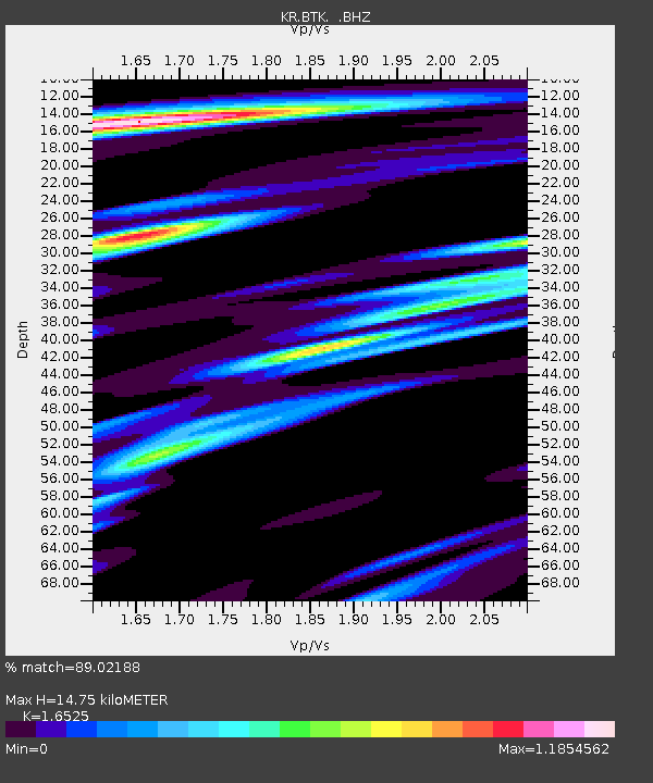
BTK Batken, Kyrgyzstan - Earthquake Result Viewer

Earthquake location: Off East Coast Of Honshu, Japan
Earthquake latitude/longitude: 40.3/143.5
Earthquake time(UTC): 2011/04/21 (111) 00:39:03 GMT
Earthquake Depth: 10 km
Earthquake Magnitude: 5.7 MW, 5.2 MS, 5.4 MB, 5.6 MW
Earthquake Catalog/Contributor: WHDF/NEIC
Network: KR Kyrgyz Digital Network
Station: BTK Batken, Kyrgyzstan
Lat/Lon: 40.06 N/70.82 E
Elevation: 1020 m
Distance: 54.0 deg
Az: 295.082 deg
Baz: 64.416 deg
Ray Param: 0.065709054
Estimated Moho Depth: 14.75 km
Estimated Crust Vp/Vs: 1.65
Assumed Crust Vp: 6.236 km/s
Estimated Crust Vs: 3.774 km/s
Estimated Crust Poisson's Ratio: 0.21
Radial Match: 89.02188 %
Radial Bump: 400
Transverse Match: 69.10066 %
Transverse Bump: 400
SOD ConfigId: 356183
Insert Time: 2011-09-30 13:53:19.391 +0000
GWidth: 2.5
Max Bumps: 400
Tol: 0.001

Signal To Noise

ChannelStoNSTALTA
KR:BTK: :BHZ:20110421T00:47:56.475015Z12.5984165.4853797E-74.3540236E-8
KR:BTK: :BHN:20110421T00:47:56.475015Z2.6748681.367879E-75.1138187E-8
KR:BTK: :BHE:20110421T00:47:56.475015Z4.638732.0899654E-74.505469E-8
Arrivals
Ps1.6 SECOND
PpPs5.9 SECOND
PsPs/PpSs7.6 SECOND