You are here: Home > Network List > TA - USArray Transportable Network (new EarthScope stations) Stations List
> Station M61A Granite Springs, NY, USA > Earthquake Result Viewer
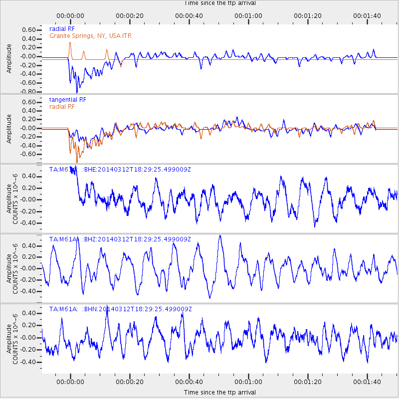
M61A Granite Springs, NY, USA - Earthquake Result Viewer
*The percent match for this event was below the threshold and hence no stack was calculated.
| Earthquake location: |
Northwest Of Kuril Islands |
| Earthquake latitude/longitude: |
52.0/153.2 |
| Earthquake time(UTC): |
2014/03/12 (071) 18:18:40 GMT |
| Earthquake Depth: |
418 km |
| Earthquake Magnitude: |
5.1 MW |
| Earthquake Catalog/Contributor: |
ISC/ISC |
|
| Network: |
TA USArray Transportable Network (new EarthScope stations) |
| Station: |
M61A Granite Springs, NY, USA |
| Lat/Lon: |
41.31 N/73.77 W |
| Elevation: |
190 m |
|
| Distance: |
78.5 deg |
| Az: |
34.186 deg |
| Baz: |
332.549 deg |
| Ray Param: |
$rayparam |
*The percent match for this event was below the threshold and hence was not used in the summary stack. |
|
| Radial Match: |
69.354675 % |
| Radial Bump: |
400 |
| Transverse Match: |
36.606544 % |
| Transverse Bump: |
400 |
| SOD ConfigId: |
3390531 |
| Insert Time: |
2019-04-10 14:49:16.000 +0000 |
| GWidth: |
2.5 |
| Max Bumps: |
400 |
| Tol: |
0.001 |
|
Signal To Noise
| Channel | StoN | STA | LTA |
| TA:M61A: :BHZ:20140312T18:29:25.499009Z | 1.4293857 | 2.942535E-7 | 2.0586013E-7 |
| TA:M61A: :BHN:20140312T18:29:25.499009Z | 1.1187586 | 3.326016E-7 | 2.9729526E-7 |
| TA:M61A: :BHE:20140312T18:29:25.499009Z | 1.0990661 | 2.0094654E-7 | 1.8283389E-7 |
| Arrivals |
| Ps | |
| PpPs | |
| PsPs/PpSs | |


