You are here: Home > Network List > TA - USArray Transportable Network (new EarthScope stations) Stations List
> Station T53A Wise, VA, USA > Earthquake Result Viewer
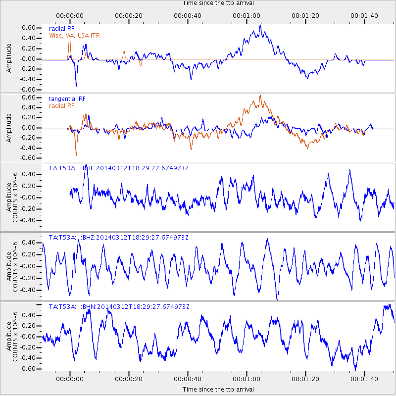
T53A Wise, VA, USA - Earthquake Result Viewer
*The percent match for this event was below the threshold and hence no stack was calculated.
| Earthquake location: |
Northwest Of Kuril Islands |
| Earthquake latitude/longitude: |
52.0/153.2 |
| Earthquake time(UTC): |
2014/03/12 (071) 18:18:40 GMT |
| Earthquake Depth: |
418 km |
| Earthquake Magnitude: |
5.1 MW |
| Earthquake Catalog/Contributor: |
ISC/ISC |
|
| Network: |
TA USArray Transportable Network (new EarthScope stations) |
| Station: |
T53A Wise, VA, USA |
| Lat/Lon: |
36.98 N/82.54 W |
| Elevation: |
818 m |
|
| Distance: |
78.9 deg |
| Az: |
42.4 deg |
| Baz: |
328.636 deg |
| Ray Param: |
$rayparam |
*The percent match for this event was below the threshold and hence was not used in the summary stack. |
|
| Radial Match: |
51.822044 % |
| Radial Bump: |
400 |
| Transverse Match: |
56.134468 % |
| Transverse Bump: |
400 |
| SOD ConfigId: |
3390531 |
| Insert Time: |
2019-04-10 14:49:45.450 +0000 |
| GWidth: |
2.5 |
| Max Bumps: |
400 |
| Tol: |
0.001 |
|
Signal To Noise
| Channel | StoN | STA | LTA |
| TA:T53A: :BHZ:20140312T18:29:27.674973Z | 1.0076654 | 2.8787144E-7 | 2.8568158E-7 |
| TA:T53A: :BHN:20140312T18:29:27.674973Z | 1.0455264 | 2.4537408E-7 | 2.3468954E-7 |
| TA:T53A: :BHE:20140312T18:29:27.674973Z | 0.9784814 | 1.3537024E-7 | 1.3834729E-7 |
| Arrivals |
| Ps | |
| PpPs | |
| PsPs/PpSs | |


