You are here: Home > Network List > TA - USArray Transportable Network (new EarthScope stations) Stations List
> Station J33A Davis, SD, USA > Earthquake Result Viewer
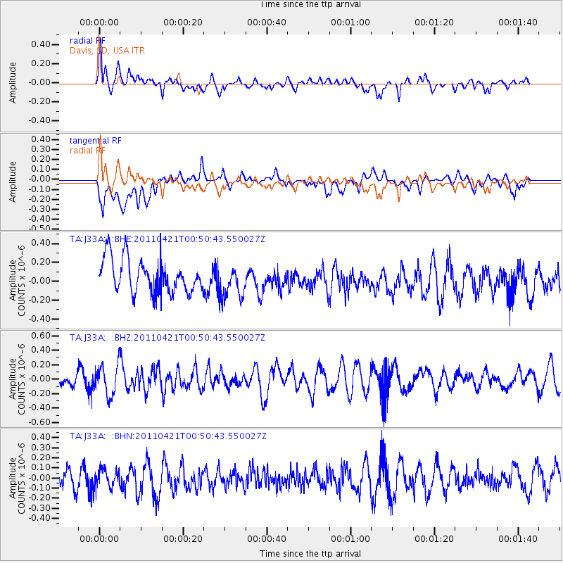
J33A Davis, SD, USA - Earthquake Result Viewer
*The percent match for this event was below the threshold and hence no stack was calculated.
| Earthquake location: |
Off East Coast Of Honshu, Japan |
| Earthquake latitude/longitude: |
40.3/143.5 |
| Earthquake time(UTC): |
2011/04/21 (111) 00:39:03 GMT |
| Earthquake Depth: |
10 km |
| Earthquake Magnitude: |
5.7 MW, 5.2 MS, 5.4 MB, 5.6 MW |
| Earthquake Catalog/Contributor: |
WHDF/NEIC |
|
| Network: |
TA USArray Transportable Network (new EarthScope stations) |
| Station: |
J33A Davis, SD, USA |
| Lat/Lon: |
43.32 N/96.97 W |
| Elevation: |
400 m |
|
| Distance: |
80.4 deg |
| Az: |
40.112 deg |
| Baz: |
317.566 deg |
| Ray Param: |
$rayparam |
*The percent match for this event was below the threshold and hence was not used in the summary stack. |
|
| Radial Match: |
56.399467 % |
| Radial Bump: |
400 |
| Transverse Match: |
54.291847 % |
| Transverse Bump: |
400 |
| SOD ConfigId: |
356183 |
| Insert Time: |
2011-09-30 14:12:26.561 +0000 |
| GWidth: |
2.5 |
| Max Bumps: |
400 |
| Tol: |
0.001 |
|
Signal To Noise
| Channel | StoN | STA | LTA |
| TA:J33A: :BHZ:20110421T00:50:43.550027Z | 1.7890738 | 2.1475896E-7 | 1.2003918E-7 |
| TA:J33A: :BHN:20110421T00:50:43.550027Z | 0.6543577 | 8.191403E-8 | 1.2518235E-7 |
| TA:J33A: :BHE:20110421T00:50:43.550027Z | 0.98684514 | 1.747639E-7 | 1.7709354E-7 |
| Arrivals |
| Ps | |
| PpPs | |
| PsPs/PpSs | |


