You are here: Home > Network List > TA - USArray Transportable Network (new EarthScope stations) Stations List
> Station F36A Milaca, MN, USA > Earthquake Result Viewer
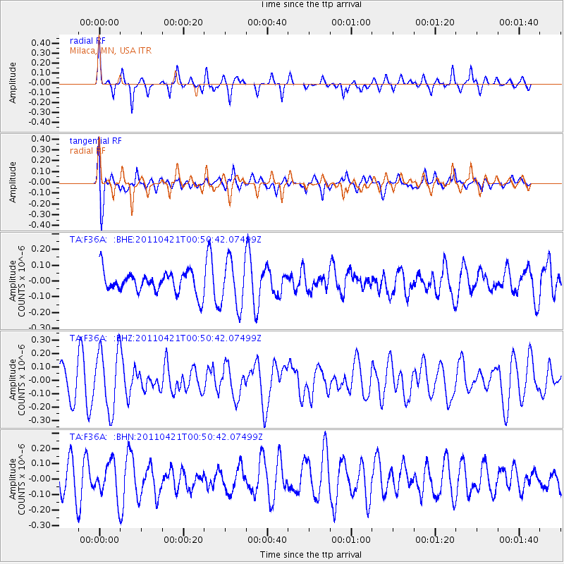
F36A Milaca, MN, USA - Earthquake Result Viewer
*The percent match for this event was below the threshold and hence no stack was calculated.
| Earthquake location: |
Off East Coast Of Honshu, Japan |
| Earthquake latitude/longitude: |
40.3/143.5 |
| Earthquake time(UTC): |
2011/04/21 (111) 00:39:03 GMT |
| Earthquake Depth: |
10 km |
| Earthquake Magnitude: |
5.7 MW, 5.2 MS, 5.4 MB, 5.6 MW |
| Earthquake Catalog/Contributor: |
WHDF/NEIC |
|
| Network: |
TA USArray Transportable Network (new EarthScope stations) |
| Station: |
F36A Milaca, MN, USA |
| Lat/Lon: |
45.86 N/93.52 W |
| Elevation: |
345 m |
|
| Distance: |
80.2 deg |
| Az: |
36.534 deg |
| Baz: |
319.372 deg |
| Ray Param: |
$rayparam |
*The percent match for this event was below the threshold and hence was not used in the summary stack. |
|
| Radial Match: |
63.887074 % |
| Radial Bump: |
336 |
| Transverse Match: |
68.483376 % |
| Transverse Bump: |
400 |
| SOD ConfigId: |
356183 |
| Insert Time: |
2011-09-30 14:15:12.014 +0000 |
| GWidth: |
2.5 |
| Max Bumps: |
400 |
| Tol: |
0.001 |
|
Signal To Noise
| Channel | StoN | STA | LTA |
| TA:F36A: :BHZ:20110421T00:50:42.07499Z | 1.9451748 | 2.30157E-7 | 1.1832202E-7 |
| TA:F36A: :BHN:20110421T00:50:42.07499Z | 1.4211928 | 1.1304424E-7 | 7.9541806E-8 |
| TA:F36A: :BHE:20110421T00:50:42.07499Z | 2.234304 | 1.4961363E-7 | 6.696207E-8 |
| Arrivals |
| Ps | |
| PpPs | |
| PsPs/PpSs | |


