You are here: Home > Network List > BK - Berkeley Digital Seismograph Network Stations List
> Station HUMO Hull Mountain, OR > Earthquake Result Viewer
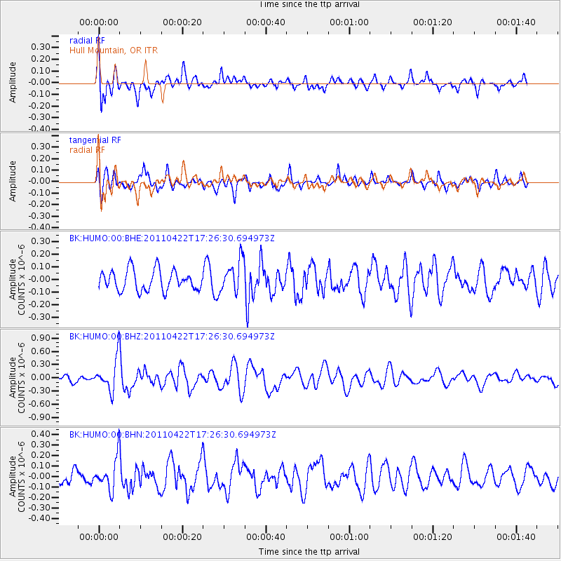
HUMO Hull Mountain, OR - Earthquake Result Viewer
*The percent match for this event was below the threshold and hence no stack was calculated.
| Earthquake location: |
Tonga Islands Region |
| Earthquake latitude/longitude: |
-22.8/-174.6 |
| Earthquake time(UTC): |
2011/04/22 (112) 17:14:51 GMT |
| Earthquake Depth: |
22 km |
| Earthquake Magnitude: |
5.5 MB, 5.2 MS, 5.5 MW |
| Earthquake Catalog/Contributor: |
WHDF/NEIC |
|
| Network: |
BK Berkeley Digital Seismograph Network |
| Station: |
HUMO Hull Mountain, OR |
| Lat/Lon: |
42.61 N/122.96 W |
| Elevation: |
555 m |
|
| Distance: |
80.6 deg |
| Az: |
35.923 deg |
| Baz: |
227.164 deg |
| Ray Param: |
$rayparam |
*The percent match for this event was below the threshold and hence was not used in the summary stack. |
|
| Radial Match: |
74.259056 % |
| Radial Bump: |
400 |
| Transverse Match: |
63.83166 % |
| Transverse Bump: |
400 |
| SOD ConfigId: |
356183 |
| Insert Time: |
2011-09-30 15:20:05.124 +0000 |
| GWidth: |
2.5 |
| Max Bumps: |
400 |
| Tol: |
0.001 |
|
Signal To Noise
| Channel | StoN | STA | LTA |
| BK:HUMO:00:BHZ:20110422T17:26:30.694973Z | 3.6171966 | 3.7671785E-7 | 1.0414636E-7 |
| BK:HUMO:00:BHN:20110422T17:26:30.694973Z | 2.761892 | 1.559999E-7 | 5.648298E-8 |
| BK:HUMO:00:BHE:20110422T17:26:30.694973Z | 1.6151458 | 1.2921667E-7 | 8.0003105E-8 |
| Arrivals |
| Ps | |
| PpPs | |
| PsPs/PpSs | |


