You are here: Home > Network List > G - GEOSCOPE Stations List
> Station INU Inuyama, Japan > Earthquake Result Viewer
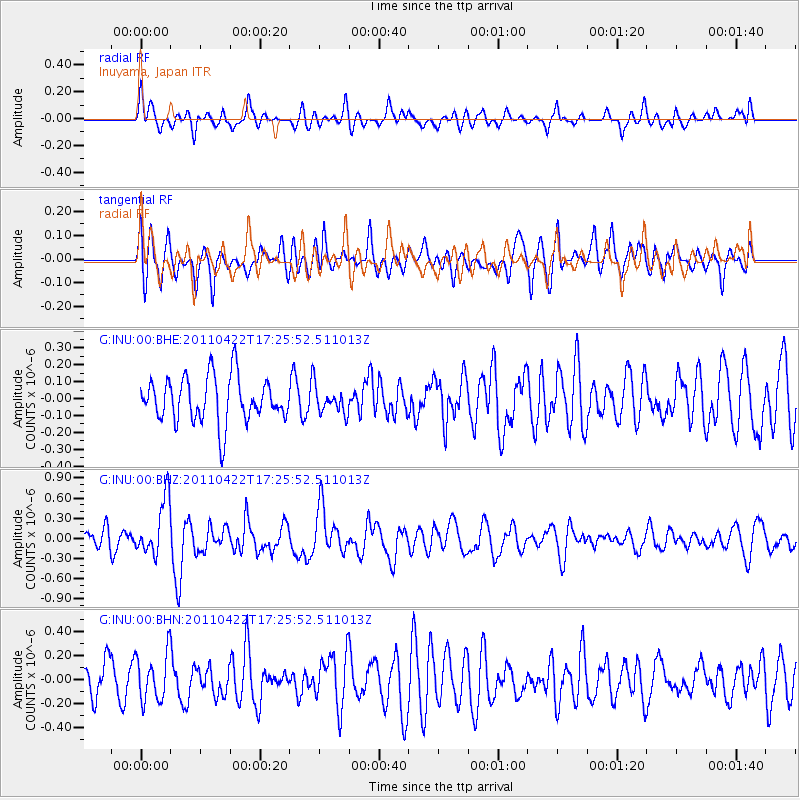
INU Inuyama, Japan - Earthquake Result Viewer
*The percent match for this event was below the threshold and hence no stack was calculated.
| Earthquake location: |
Tonga Islands Region |
| Earthquake latitude/longitude: |
-22.8/-174.6 |
| Earthquake time(UTC): |
2011/04/22 (112) 17:14:51 GMT |
| Earthquake Depth: |
22 km |
| Earthquake Magnitude: |
5.5 MB, 5.2 MS, 5.5 MW |
| Earthquake Catalog/Contributor: |
WHDF/NEIC |
|
| Network: |
G GEOSCOPE |
| Station: |
INU Inuyama, Japan |
| Lat/Lon: |
35.35 N/137.03 E |
| Elevation: |
132 m |
|
| Distance: |
73.8 deg |
| Az: |
320.478 deg |
| Baz: |
134.082 deg |
| Ray Param: |
$rayparam |
*The percent match for this event was below the threshold and hence was not used in the summary stack. |
|
| Radial Match: |
54.017624 % |
| Radial Bump: |
400 |
| Transverse Match: |
59.69251 % |
| Transverse Bump: |
400 |
| SOD ConfigId: |
356183 |
| Insert Time: |
2011-09-30 15:33:26.441 +0000 |
| GWidth: |
2.5 |
| Max Bumps: |
400 |
| Tol: |
0.001 |
|
Signal To Noise
| Channel | StoN | STA | LTA |
| G:INU:00:BHZ:20110422T17:25:52.511013Z | 2.0756233 | 4.1345913E-7 | 1.9919756E-7 |
| G:INU:00:BHN:20110422T17:25:52.511013Z | 1.4051116 | 1.9912486E-7 | 1.4171462E-7 |
| G:INU:00:BHE:20110422T17:25:52.511013Z | 0.55761075 | 7.536136E-8 | 1.351505E-7 |
| Arrivals |
| Ps | |
| PpPs | |
| PsPs/PpSs | |


