You are here: Home > Network List > TA - USArray Transportable Network (new EarthScope stations) Stations List
> Station L02D Cave Junction, OR, USA > Earthquake Result Viewer
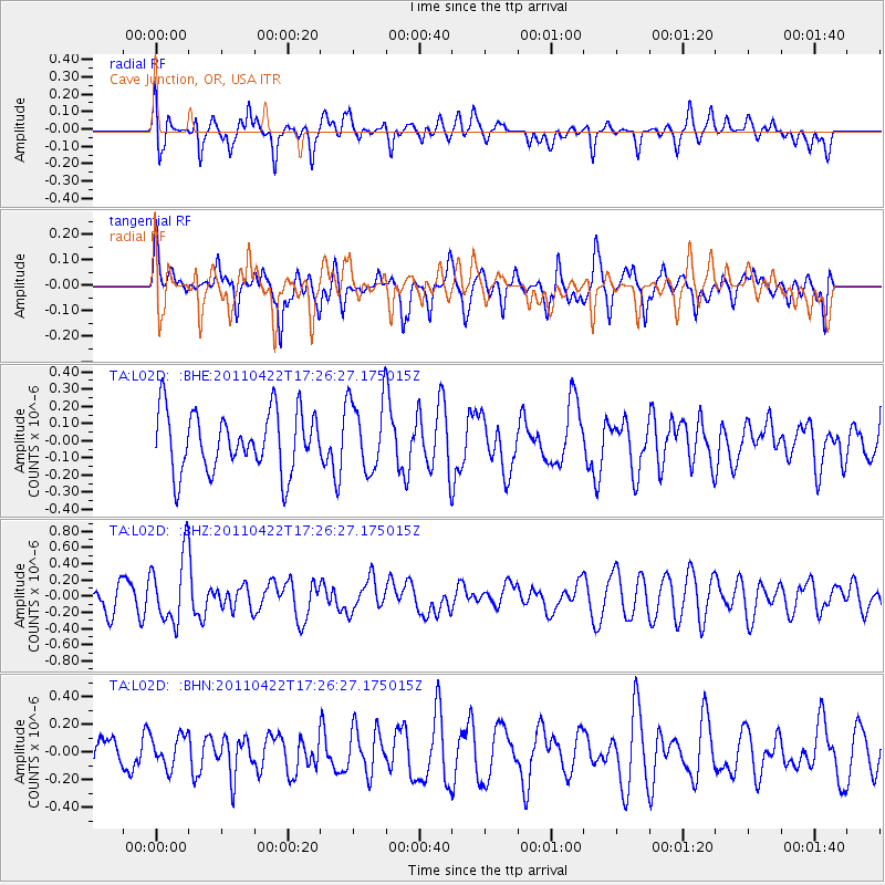
L02D Cave Junction, OR, USA - Earthquake Result Viewer
*The percent match for this event was below the threshold and hence no stack was calculated.
| Earthquake location: |
Tonga Islands Region |
| Earthquake latitude/longitude: |
-22.8/-174.6 |
| Earthquake time(UTC): |
2011/04/22 (112) 17:14:51 GMT |
| Earthquake Depth: |
22 km |
| Earthquake Magnitude: |
5.5 MB, 5.2 MS, 5.5 MW |
| Earthquake Catalog/Contributor: |
WHDF/NEIC |
|
| Network: |
TA USArray Transportable Network (new EarthScope stations) |
| Station: |
L02D Cave Junction, OR, USA |
| Lat/Lon: |
42.16 N/123.60 W |
| Elevation: |
458 m |
|
| Distance: |
80.0 deg |
| Az: |
35.924 deg |
| Baz: |
226.73 deg |
| Ray Param: |
$rayparam |
*The percent match for this event was below the threshold and hence was not used in the summary stack. |
|
| Radial Match: |
58.718475 % |
| Radial Bump: |
400 |
| Transverse Match: |
57.402008 % |
| Transverse Bump: |
400 |
| SOD ConfigId: |
356183 |
| Insert Time: |
2011-09-30 16:01:39.971 +0000 |
| GWidth: |
2.5 |
| Max Bumps: |
400 |
| Tol: |
0.001 |
|
Signal To Noise
| Channel | StoN | STA | LTA |
| TA:L02D: :BHZ:20110422T17:26:27.175015Z | 2.1924186 | 4.177945E-7 | 1.905633E-7 |
| TA:L02D: :BHN:20110422T17:26:27.175015Z | 0.76195353 | 1.137936E-7 | 1.4934453E-7 |
| TA:L02D: :BHE:20110422T17:26:27.175015Z | 1.2301657 | 2.1189733E-7 | 1.7225103E-7 |
| Arrivals |
| Ps | |
| PpPs | |
| PsPs/PpSs | |


