You are here: Home > Network List > TA - USArray Transportable Network (new EarthScope stations) Stations List
> Station J01D Myrtle Point, OR, USA > Earthquake Result Viewer
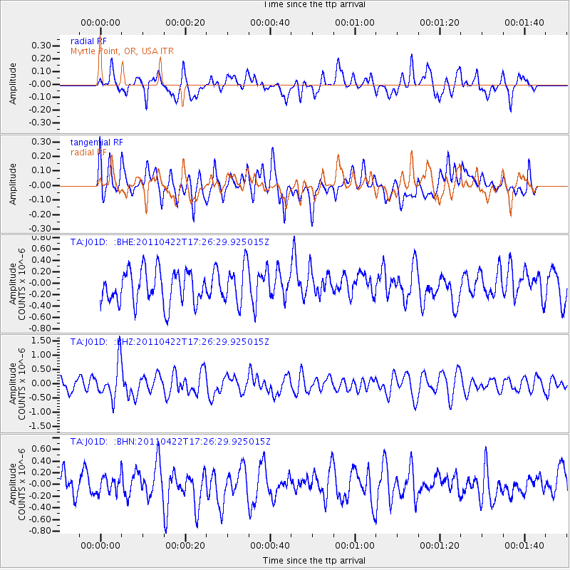
J01D Myrtle Point, OR, USA - Earthquake Result Viewer
*The percent match for this event was below the threshold and hence no stack was calculated.
| Earthquake location: |
Tonga Islands Region |
| Earthquake latitude/longitude: |
-22.8/-174.6 |
| Earthquake time(UTC): |
2011/04/22 (112) 17:14:51 GMT |
| Earthquake Depth: |
22 km |
| Earthquake Magnitude: |
5.5 MB, 5.2 MS, 5.5 MW |
| Earthquake Catalog/Contributor: |
WHDF/NEIC |
|
| Network: |
TA USArray Transportable Network (new EarthScope stations) |
| Station: |
J01D Myrtle Point, OR, USA |
| Lat/Lon: |
43.16 N/123.93 W |
| Elevation: |
131 m |
|
| Distance: |
80.5 deg |
| Az: |
35.016 deg |
| Baz: |
226.354 deg |
| Ray Param: |
$rayparam |
*The percent match for this event was below the threshold and hence was not used in the summary stack. |
|
| Radial Match: |
46.775055 % |
| Radial Bump: |
400 |
| Transverse Match: |
52.35775 % |
| Transverse Bump: |
400 |
| SOD ConfigId: |
356183 |
| Insert Time: |
2011-09-30 16:15:29.842 +0000 |
| GWidth: |
2.5 |
| Max Bumps: |
400 |
| Tol: |
0.001 |
|
Signal To Noise
| Channel | StoN | STA | LTA |
| TA:J01D: :BHZ:20110422T17:26:29.925015Z | 2.3246715 | 6.3981315E-7 | 2.7522734E-7 |
| TA:J01D: :BHN:20110422T17:26:29.925015Z | 0.63840216 | 1.401538E-7 | 2.1953844E-7 |
| TA:J01D: :BHE:20110422T17:26:29.925015Z | 1.2206336 | 3.496205E-7 | 2.8642543E-7 |
| Arrivals |
| Ps | |
| PpPs | |
| PsPs/PpSs | |


