You are here: Home > Network List > TA - USArray Transportable Network (new EarthScope stations) Stations List
> Station R11A Troy Canyon, Currant, NV, USA > Earthquake Result Viewer
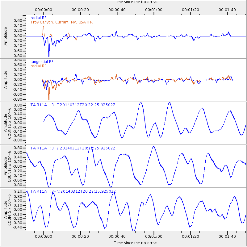
R11A Troy Canyon, Currant, NV, USA - Earthquake Result Viewer
*The percent match for this event was below the threshold and hence no stack was calculated.
| Earthquake location: |
Tonga Islands Region |
| Earthquake latitude/longitude: |
-23.4/-175.3 |
| Earthquake time(UTC): |
2014/03/12 (071) 20:10:34 GMT |
| Earthquake Depth: |
30 km |
| Earthquake Magnitude: |
5.0 MW |
| Earthquake Catalog/Contributor: |
ISC/ISC |
|
| Network: |
TA USArray Transportable Network (new EarthScope stations) |
| Station: |
R11A Troy Canyon, Currant, NV, USA |
| Lat/Lon: |
38.35 N/115.59 W |
| Elevation: |
1756 m |
|
| Distance: |
83.1 deg |
| Az: |
43.163 deg |
| Baz: |
233.092 deg |
| Ray Param: |
$rayparam |
*The percent match for this event was below the threshold and hence was not used in the summary stack. |
|
| Radial Match: |
90.18731 % |
| Radial Bump: |
400 |
| Transverse Match: |
70.03933 % |
| Transverse Bump: |
400 |
| SOD ConfigId: |
3390531 |
| Insert Time: |
2019-04-10 15:03:20.159 +0000 |
| GWidth: |
2.5 |
| Max Bumps: |
400 |
| Tol: |
0.001 |
|
Signal To Noise
| Channel | StoN | STA | LTA |
| TA:R11A: :BHZ:20140312T20:22:25.92502Z | 1.6758558 | 5.5643625E-7 | 3.3203114E-7 |
| TA:R11A: :BHN:20140312T20:22:25.92502Z | 1.655652 | 2.809064E-7 | 1.6966511E-7 |
| TA:R11A: :BHE:20140312T20:22:25.92502Z | 0.981529 | 2.9895853E-7 | 3.0458452E-7 |
| Arrivals |
| Ps | |
| PpPs | |
| PsPs/PpSs | |


