You are here: Home > Network List > CI - Caltech Regional Seismic Network Stations List
> Station SMM Simmler, CA, USA > Earthquake Result Viewer
SMM Simmler, CA, USA - Earthquake Result Viewer
| Earthquake location: |
Solomon Islands |
| Earthquake latitude/longitude: |
-10.4/161.2 |
| Earthquake time(UTC): |
2011/04/23 (113) 04:16:54 GMT |
| Earthquake Depth: |
79 km |
| Earthquake Magnitude: |
6.7 MB, 6.8 MW, 6.8 MW |
| Earthquake Catalog/Contributor: |
WHDF/NEIC |
|
| Network: |
CI Caltech Regional Seismic Network |
| Station: |
SMM Simmler, CA, USA |
| Lat/Lon: |
35.31 N/120.00 W |
| Elevation: |
599 m |
|
| Distance: |
86.9 deg |
| Az: |
53.456 deg |
| Baz: |
255.13 deg |
| Ray Param: |
0.043523043 |
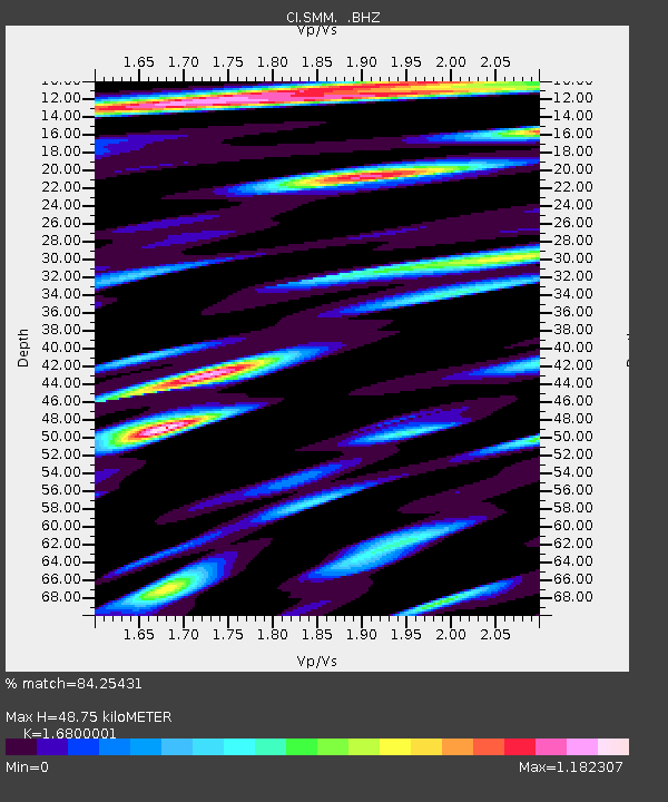
| Estimated Moho Depth: |
48.75 km |
| Estimated Crust Vp/Vs: |
1.68 |
| Assumed Crust Vp: |
6.1 km/s |
| Estimated Crust Vs: |
3.631 km/s |
| Estimated Crust Poisson's Ratio: |
0.23 |
|
| Radial Match: |
84.25431 % |
| Radial Bump: |
400 |
| Transverse Match: |
76.5364 % |
| Transverse Bump: |
400 |
| SOD ConfigId: |
356183 |
| Insert Time: |
2011-10-01 03:02:45.659 +0000 |
| GWidth: |
2.5 |
| Max Bumps: |
400 |
| Tol: |
0.001 |
|
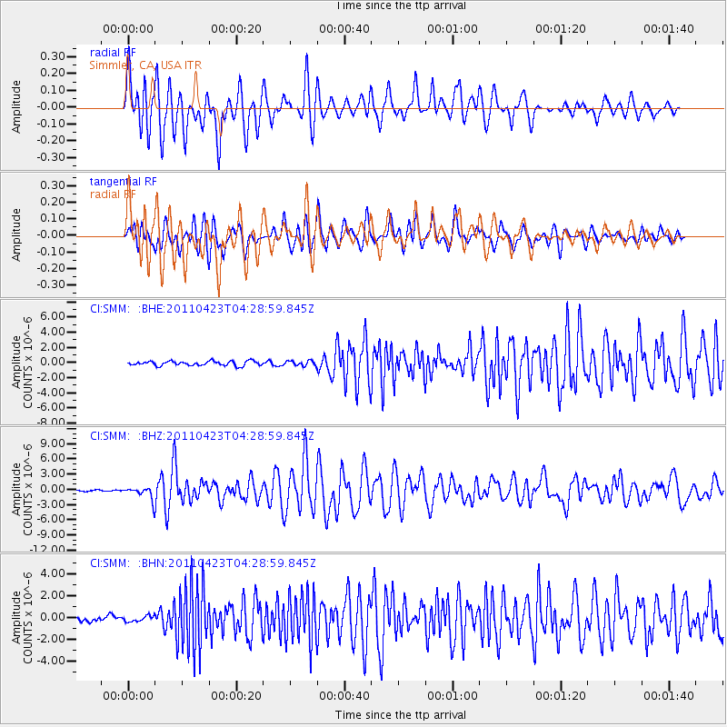
Signal To Noise
| Channel | StoN | STA | LTA |
| CI:SMM: :BHZ:20110423T04:28:59.845Z | 7.068033 | 1.2598823E-6 | 1.7825077E-7 |
| CI:SMM: :BHN:20110423T04:28:59.845Z | 1.0194787 | 2.5746124E-7 | 2.5254207E-7 |
| CI:SMM: :BHE:20110423T04:28:59.845Z | 1.0922476 | 3.2446633E-7 | 2.9706297E-7 |
| Arrivals |
| Ps | 5.6 SECOND |
| PpPs | 21 SECOND |
| PsPs/PpSs | 27 SECOND |


