You are here: Home > Network List > CI - Caltech Regional Seismic Network Stations List
> Station TUQ Turquiose Mountain, Baker, CA, USA > Earthquake Result Viewer
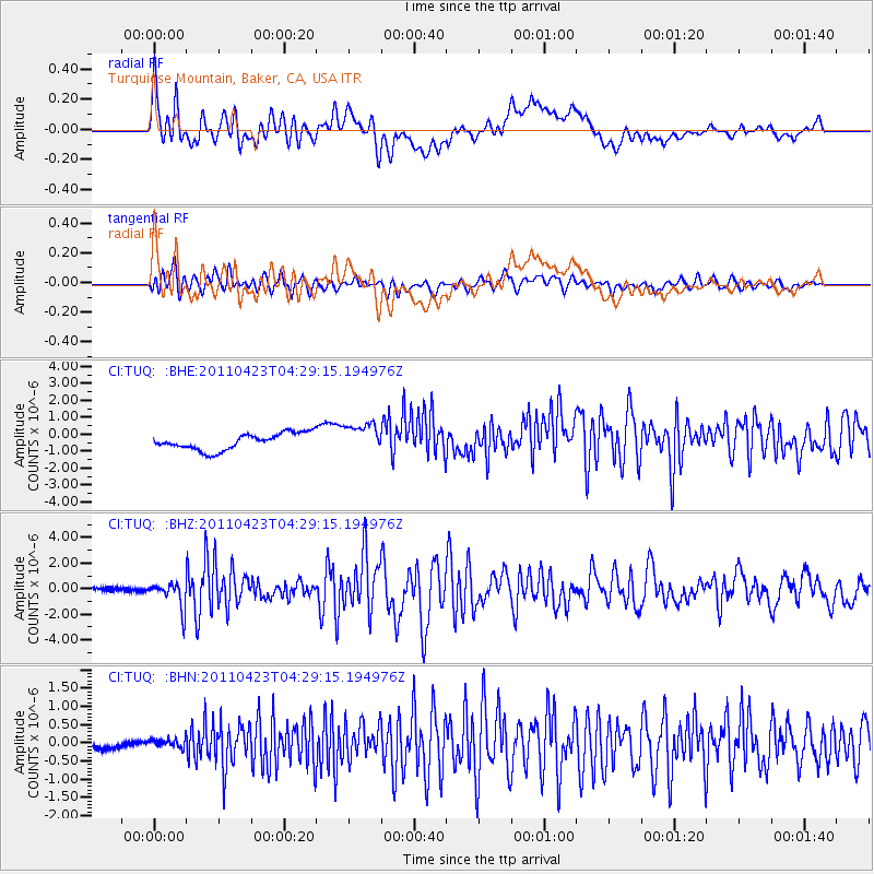
TUQ Turquiose Mountain, Baker, CA, USA - Earthquake Result Viewer
*The percent match for this event was below the threshold and hence no stack was calculated.
| Earthquake location: |
Solomon Islands |
| Earthquake latitude/longitude: |
-10.4/161.2 |
| Earthquake time(UTC): |
2011/04/23 (113) 04:16:54 GMT |
| Earthquake Depth: |
79 km |
| Earthquake Magnitude: |
6.7 MB, 6.8 MW, 6.8 MW |
| Earthquake Catalog/Contributor: |
WHDF/NEIC |
|
| Network: |
CI Caltech Regional Seismic Network |
| Station: |
TUQ Turquiose Mountain, Baker, CA, USA |
| Lat/Lon: |
35.44 N/115.92 W |
| Elevation: |
1350 m |
|
| Distance: |
90.2 deg |
| Az: |
54.125 deg |
| Baz: |
257.494 deg |
| Ray Param: |
$rayparam |
*The percent match for this event was below the threshold and hence was not used in the summary stack. |
|
| Radial Match: |
66.431725 % |
| Radial Bump: |
400 |
| Transverse Match: |
80.83895 % |
| Transverse Bump: |
400 |
| SOD ConfigId: |
356183 |
| Insert Time: |
2011-10-01 03:06:41.723 +0000 |
| GWidth: |
2.5 |
| Max Bumps: |
400 |
| Tol: |
0.001 |
|
Signal To Noise
| Channel | StoN | STA | LTA |
| CI:TUQ: :BHZ:20110423T04:29:15.194976Z | 6.49432 | 1.010319E-6 | 1.5556964E-7 |
| CI:TUQ: :BHN:20110423T04:29:15.194976Z | 1.0174099 | 1.2351654E-7 | 1.2140293E-7 |
| CI:TUQ: :BHE:20110423T04:29:15.194976Z | 1.7604616 | 8.581374E-7 | 4.874503E-7 |
| Arrivals |
| Ps | |
| PpPs | |
| PsPs/PpSs | |


