You are here: Home > Network List > MY - Malaysian National Seismic Network Stations List
> Station KSM Kuching > Earthquake Result Viewer
KSM Kuching - Earthquake Result Viewer
| Earthquake location: |
Solomon Islands |
| Earthquake latitude/longitude: |
-10.4/161.2 |
| Earthquake time(UTC): |
2011/04/23 (113) 04:16:54 GMT |
| Earthquake Depth: |
79 km |
| Earthquake Magnitude: |
6.7 MB, 6.8 MW, 6.8 MW |
| Earthquake Catalog/Contributor: |
WHDF/NEIC |
|
| Network: |
MY Malaysian National Seismic Network |
| Station: |
KSM Kuching |
| Lat/Lon: |
1.47 N/110.31 E |
| Elevation: |
66 m |
|
| Distance: |
52.0 deg |
| Az: |
280.084 deg |
| Baz: |
104.308 deg |
| Ray Param: |
0.06681667 |
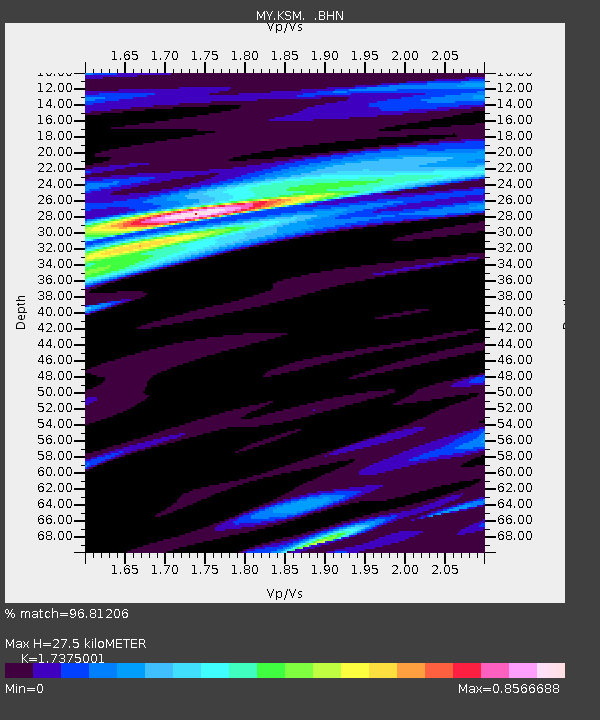
| Estimated Moho Depth: |
27.5 km |
| Estimated Crust Vp/Vs: |
1.74 |
| Assumed Crust Vp: |
6.468 km/s |
| Estimated Crust Vs: |
3.722 km/s |
| Estimated Crust Poisson's Ratio: |
0.25 |
|
| Radial Match: |
96.81206 % |
| Radial Bump: |
400 |
| Transverse Match: |
89.729416 % |
| Transverse Bump: |
400 |
| SOD ConfigId: |
356183 |
| Insert Time: |
2011-10-01 03:25:30.816 +0000 |
| GWidth: |
2.5 |
| Max Bumps: |
400 |
| Tol: |
0.001 |
|

Signal To Noise
| Channel | StoN | STA | LTA |
| MY:KSM: :BHZ:20110423T04:25:25.369994Z | 17.229528 | 1.6140451E-6 | 9.3679006E-8 |
| MY:KSM: :BHN:20110423T04:25:25.369994Z | 3.9069498 | 3.274695E-7 | 8.381718E-8 |
| MY:KSM: :BHE:20110423T04:25:25.369994Z | 8.646663 | 4.8067267E-7 | 5.5590544E-8 |
| Arrivals |
| Ps | 3.3 SECOND |
| PpPs | 11 SECOND |
| PsPs/PpSs | 14 SECOND |


