You are here: Home > Network List > TA - USArray Transportable Network (new EarthScope stations) Stations List
> Station N02D Trinity Center, CA, USA > Earthquake Result Viewer
N02D Trinity Center, CA, USA - Earthquake Result Viewer
| Earthquake location: |
Solomon Islands |
| Earthquake latitude/longitude: |
-10.4/161.2 |
| Earthquake time(UTC): |
2011/04/23 (113) 04:16:54 GMT |
| Earthquake Depth: |
79 km |
| Earthquake Magnitude: |
6.7 MB, 6.8 MW, 6.8 MW |
| Earthquake Catalog/Contributor: |
WHDF/NEIC |
|
| Network: |
TA USArray Transportable Network (new EarthScope stations) |
| Station: |
N02D Trinity Center, CA, USA |
| Lat/Lon: |
40.97 N/122.71 W |
| Elevation: |
937 m |
|
| Distance: |
86.4 deg |
| Az: |
47.427 deg |
| Baz: |
253.113 deg |
| Ray Param: |
0.043895442 |
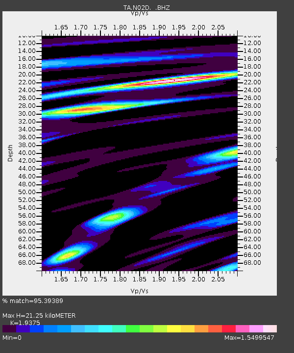
| Estimated Moho Depth: |
21.25 km |
| Estimated Crust Vp/Vs: |
1.94 |
| Assumed Crust Vp: |
6.566 km/s |
| Estimated Crust Vs: |
3.389 km/s |
| Estimated Crust Poisson's Ratio: |
0.32 |
|
| Radial Match: |
95.39389 % |
| Radial Bump: |
400 |
| Transverse Match: |
87.698555 % |
| Transverse Bump: |
400 |
| SOD ConfigId: |
356183 |
| Insert Time: |
2011-10-01 03:32:54.609 +0000 |
| GWidth: |
2.5 |
| Max Bumps: |
400 |
| Tol: |
0.001 |
|
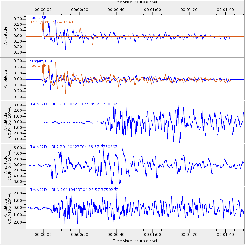
Signal To Noise
| Channel | StoN | STA | LTA |
| TA:N02D: :BHZ:20110423T04:28:57.375029Z | 12.581807 | 1.0760122E-6 | 8.5521265E-8 |
| TA:N02D: :BHN:20110423T04:28:57.375029Z | 1.2187914 | 1.4159473E-7 | 1.16176345E-7 |
| TA:N02D: :BHE:20110423T04:28:57.375029Z | 3.1859064 | 3.2612385E-7 | 1.02364545E-7 |
| Arrivals |
| Ps | 3.1 SECOND |
| PpPs | 9.3 SECOND |
| PsPs/PpSs | 12 SECOND |


