You are here: Home > Network List > TA - USArray Transportable Network (new EarthScope stations) Stations List
> Station L04D Klamath Falls, OR, USA > Earthquake Result Viewer
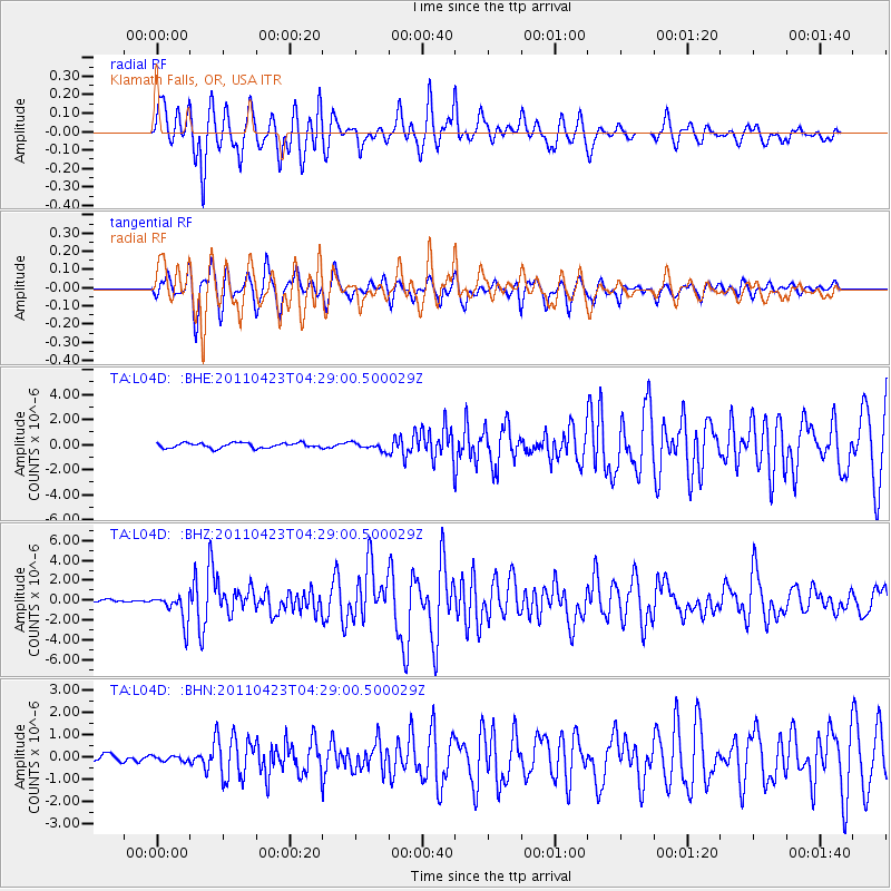
L04D Klamath Falls, OR, USA - Earthquake Result Viewer
*The percent match for this event was below the threshold and hence no stack was calculated.
| Earthquake location: |
Solomon Islands |
| Earthquake latitude/longitude: |
-10.4/161.2 |
| Earthquake time(UTC): |
2011/04/23 (113) 04:16:54 GMT |
| Earthquake Depth: |
79 km |
| Earthquake Magnitude: |
6.7 MB, 6.8 MW, 6.8 MW |
| Earthquake Catalog/Contributor: |
WHDF/NEIC |
|
| Network: |
TA USArray Transportable Network (new EarthScope stations) |
| Station: |
L04D Klamath Falls, OR, USA |
| Lat/Lon: |
42.22 N/122.30 W |
| Elevation: |
1437 m |
|
| Distance: |
87.1 deg |
| Az: |
46.322 deg |
| Baz: |
253.316 deg |
| Ray Param: |
$rayparam |
*The percent match for this event was below the threshold and hence was not used in the summary stack. |
|
| Radial Match: |
83.785576 % |
| Radial Bump: |
400 |
| Transverse Match: |
87.43792 % |
| Transverse Bump: |
400 |
| SOD ConfigId: |
356183 |
| Insert Time: |
2011-10-01 03:33:25.096 +0000 |
| GWidth: |
2.5 |
| Max Bumps: |
400 |
| Tol: |
0.001 |
|
Signal To Noise
| Channel | StoN | STA | LTA |
| TA:L04D: :BHZ:20110423T04:29:00.500029Z | 10.861215 | 1.4339371E-6 | 1.3202364E-7 |
| TA:L04D: :BHN:20110423T04:29:00.500029Z | 0.7267501 | 1.1227412E-7 | 1.5448794E-7 |
| TA:L04D: :BHE:20110423T04:29:00.500029Z | 1.565169 | 3.1440388E-7 | 2.0087536E-7 |
| Arrivals |
| Ps | |
| PpPs | |
| PsPs/PpSs | |


