You are here: Home > Network List > TA - USArray Transportable Network (new EarthScope stations) Stations List
> Station F05D White Salmon, WA, USA > Earthquake Result Viewer
F05D White Salmon, WA, USA - Earthquake Result Viewer

| Earthquake location: |
Solomon Islands |
| Earthquake latitude/longitude: |
-10.4/161.2 |
| Earthquake time(UTC): |
2011/04/23 (113) 04:16:54 GMT |
| Earthquake Depth: |
79 km |
| Earthquake Magnitude: |
6.7 MB, 6.8 MW, 6.8 MW |
| Earthquake Catalog/Contributor: |
WHDF/NEIC |
|
| Network: |
TA USArray Transportable Network (new EarthScope stations) |
| Station: |
F05D White Salmon, WA, USA |
| Lat/Lon: |
45.89 N/121.46 W |
| Elevation: |
472 m |
|
| Distance: |
88.7 deg |
| Az: |
42.976 deg |
| Baz: |
253.779 deg |
| Ray Param: |
0.04223228 |
| Estimated Moho Depth: |
14.5 km |
| Estimated Crust Vp/Vs: |
1.60 |
| Assumed Crust Vp: |
6.597 km/s |
| Estimated Crust Vs: |
4.123 km/s |
| Estimated Crust Poisson's Ratio: |
0.18 |
|
| Radial Match: |
90.77062 % |
| Radial Bump: |
400 |
| Transverse Match: |
79.27665 % |
| Transverse Bump: |
400 |
| SOD ConfigId: |
356183 |
| Insert Time: |
2011-10-01 03:36:29.264 +0000 |
| GWidth: |
2.5 |
| Max Bumps: |
400 |
| Tol: |
0.001 |
|
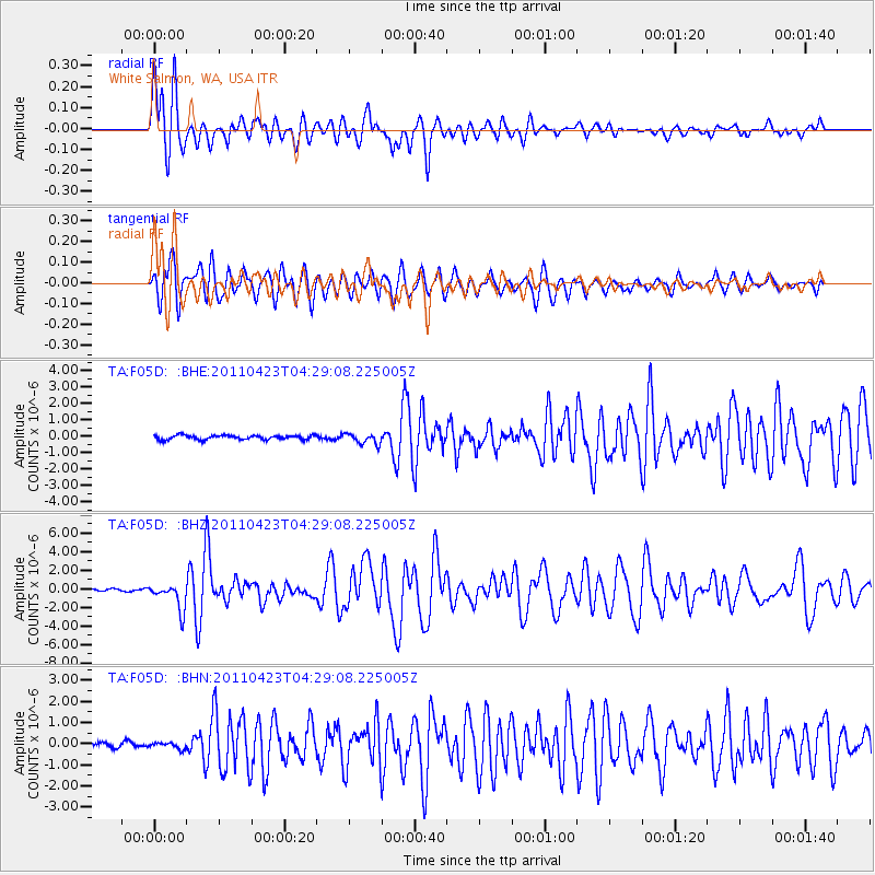
Signal To Noise
| Channel | StoN | STA | LTA |
| TA:F05D: :BHZ:20110423T04:29:08.225005Z | 7.7463546 | 1.3975867E-6 | 1.8041864E-7 |
| TA:F05D: :BHN:20110423T04:29:08.225005Z | 1.0833802 | 1.4391838E-7 | 1.3284198E-7 |
| TA:F05D: :BHE:20110423T04:29:08.225005Z | 2.4987466 | 3.309363E-7 | 1.3244093E-7 |
| Arrivals |
| Ps | 1.4 SECOND |
| PpPs | 5.6 SECOND |
| PsPs/PpSs | 6.9 SECOND |


