You are here: Home > Network List > UW - Pacific Northwest Regional Seismic Network Stations List
> Station FISH Seaside, OR, USA > Earthquake Result Viewer
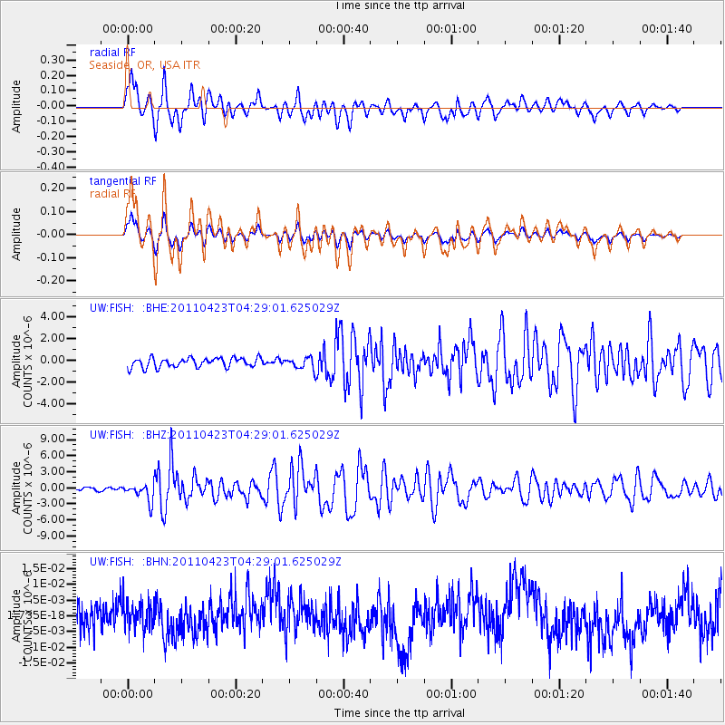
FISH Seaside, OR, USA - Earthquake Result Viewer
*The percent match for this event was below the threshold and hence no stack was calculated.
| Earthquake location: |
Solomon Islands |
| Earthquake latitude/longitude: |
-10.4/161.2 |
| Earthquake time(UTC): |
2011/04/23 (113) 04:16:54 GMT |
| Earthquake Depth: |
79 km |
| Earthquake Magnitude: |
6.7 MB, 6.8 MW, 6.8 MW |
| Earthquake Catalog/Contributor: |
WHDF/NEIC |
|
| Network: |
UW Pacific Northwest Regional Seismic Network |
| Station: |
FISH Seaside, OR, USA |
| Lat/Lon: |
45.93 N/123.56 W |
| Elevation: |
325 m |
|
| Distance: |
87.3 deg |
| Az: |
42.505 deg |
| Baz: |
252.259 deg |
| Ray Param: |
$rayparam |
*The percent match for this event was below the threshold and hence was not used in the summary stack. |
|
| Radial Match: |
78.046585 % |
| Radial Bump: |
400 |
| Transverse Match: |
78.06115 % |
| Transverse Bump: |
400 |
| SOD ConfigId: |
356183 |
| Insert Time: |
2011-10-01 03:49:22.182 +0000 |
| GWidth: |
2.5 |
| Max Bumps: |
400 |
| Tol: |
0.001 |
|
Signal To Noise
| Channel | StoN | STA | LTA |
| UW:FISH: :BHZ:20110423T04:29:01.625029Z | 4.798198 | 1.6500601E-6 | 3.4389163E-7 |
| UW:FISH: :BHN:20110423T04:29:01.625029Z | 0.8645201 | 4.3019095E-9 | 4.976067E-9 |
| UW:FISH: :BHE:20110423T04:29:01.625029Z | 1.2851753 | 5.568751E-7 | 4.333067E-7 |
| Arrivals |
| Ps | |
| PpPs | |
| PsPs/PpSs | |


