You are here: Home > Network List > UW - Pacific Northwest Regional Seismic Network Stations List
> Station TUCA Wood Farm, Starbuck, WA, USA > Earthquake Result Viewer
TUCA Wood Farm, Starbuck, WA, USA - Earthquake Result Viewer
| Earthquake location: |
Solomon Islands |
| Earthquake latitude/longitude: |
-10.4/161.2 |
| Earthquake time(UTC): |
2011/04/23 (113) 04:16:54 GMT |
| Earthquake Depth: |
79 km |
| Earthquake Magnitude: |
6.7 MB, 6.8 MW, 6.8 MW |
| Earthquake Catalog/Contributor: |
WHDF/NEIC |
|
| Network: |
UW Pacific Northwest Regional Seismic Network |
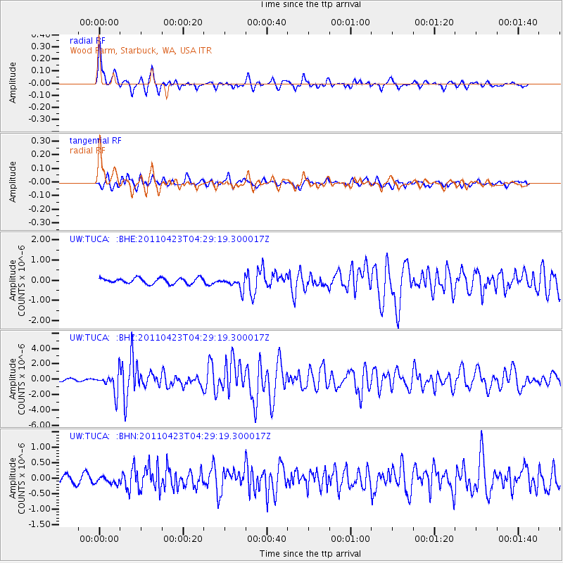
| Station: |
TUCA Wood Farm, Starbuck, WA, USA |
| Lat/Lon: |
46.51 N/118.15 W |
| Elevation: |
304 m |
|
| Distance: |
91.1 deg |
| Az: |
42.966 deg |
| Baz: |
256.163 deg |
| Ray Param: |
0.04161215 |
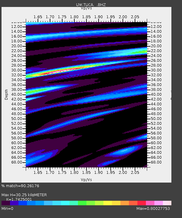
| Estimated Moho Depth: |
30.25 km |
| Estimated Crust Vp/Vs: |
1.74 |
| Assumed Crust Vp: |
6.419 km/s |
| Estimated Crust Vs: |
3.684 km/s |
| Estimated Crust Poisson's Ratio: |
0.25 |
|
| Radial Match: |
90.26176 % |
| Radial Bump: |
400 |
| Transverse Match: |
80.00173 % |
| Transverse Bump: |
400 |
| SOD ConfigId: |
356183 |
| Insert Time: |
2011-10-01 03:51:31.378 +0000 |
| GWidth: |
2.5 |
| Max Bumps: |
400 |
| Tol: |
0.001 |
|
Signal To Noise
| Channel | StoN | STA | LTA |
| UW:TUCA: :BHZ:20110423T04:29:19.300017Z | 9.974544 | 1.3864461E-6 | 1.3899846E-7 |
| UW:TUCA: :BHN:20110423T04:29:19.300017Z | 1.1160764 | 1.2259196E-7 | 1.09841906E-7 |
| UW:TUCA: :BHE:20110423T04:29:19.300017Z | 2.3164213 | 3.203524E-7 | 1.3829626E-7 |
| Arrivals |
| Ps | 3.6 SECOND |
| PpPs | 13 SECOND |
| PsPs/PpSs | 16 SECOND |


