You are here: Home > Network List > UW - Pacific Northwest Regional Seismic Network Stations List
> Station DOSE Dosewallips old TA.C04A, WA > Earthquake Result Viewer
DOSE Dosewallips old TA.C04A, WA - Earthquake Result Viewer
| Earthquake location: |
Solomon Islands |
| Earthquake latitude/longitude: |
-10.4/161.2 |
| Earthquake time(UTC): |
2011/04/23 (113) 04:16:54 GMT |
| Earthquake Depth: |
79 km |
| Earthquake Magnitude: |
6.7 MB, 6.8 MW, 6.8 MW |
| Earthquake Catalog/Contributor: |
WHDF/NEIC |
|
| Network: |
UW Pacific Northwest Regional Seismic Network |
| Station: |
DOSE Dosewallips old TA.C04A, WA |
| Lat/Lon: |
47.72 N/122.97 W |
| Elevation: |
53 m |
|
| Distance: |
88.2 deg |
| Az: |
40.921 deg |
| Baz: |
252.625 deg |
| Ray Param: |
0.042577118 |
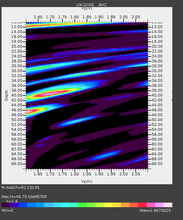
| Estimated Moho Depth: |
46.75 km |
| Estimated Crust Vp/Vs: |
1.60 |
| Assumed Crust Vp: |
6.566 km/s |
| Estimated Crust Vs: |
4.104 km/s |
| Estimated Crust Poisson's Ratio: |
0.18 |
|
| Radial Match: |
92.15145 % |
| Radial Bump: |
400 |
| Transverse Match: |
92.461716 % |
| Transverse Bump: |
345 |
| SOD ConfigId: |
356183 |
| Insert Time: |
2011-10-01 03:52:59.481 +0000 |
| GWidth: |
2.5 |
| Max Bumps: |
400 |
| Tol: |
0.001 |
|

Signal To Noise
| Channel | StoN | STA | LTA |
| UW:DOSE: :BHZ:20110423T04:29:06.024993Z | 15.439097 | 8.626724E-7 | 5.587583E-8 |
| UW:DOSE: :BHN:20110423T04:29:06.024993Z | 1.8528949 | 1.4631873E-7 | 7.896764E-8 |
| UW:DOSE: :BHE:20110423T04:29:06.024993Z | 2.3951225 | 2.9288753E-7 | 1.2228499E-7 |
| Arrivals |
| Ps | 4.4 SECOND |
| PpPs | 18 SECOND |
| PsPs/PpSs | 22 SECOND |


