You are here: Home > Network List > NE - New England Seismic Network Stations List
> Station EMMW Machias, ME, USA > Earthquake Result Viewer
EMMW Machias, ME, USA - Earthquake Result Viewer
*The percent match for this event was below the threshold and hence no stack was calculated.
| Earthquake location: |
Near Coast Of Nicaragua |
| Earthquake latitude/longitude: |
12.6/-87.8 |
| Earthquake time(UTC): |
2014/03/13 (072) 05:45:21 GMT |
| Earthquake Depth: |
78 km |
| Earthquake Magnitude: |
4.9 MW |
| Earthquake Catalog/Contributor: |
ISC/ISC |
|
| Network: |
NE New England Seismic Network |
| Station: |
EMMW Machias, ME, USA |
| Lat/Lon: |
44.71 N/67.46 W |
| Elevation: |
35 m |
|
| Distance: |
36.4 deg |
| Az: |
24.687 deg |
| Baz: |
214.872 deg |
| Ray Param: |
$rayparam |
*The percent match for this event was below the threshold and hence was not used in the summary stack. |
|
| Radial Match: |
54.923687 % |
| Radial Bump: |
400 |
| Transverse Match: |
65.21708 % |
| Transverse Bump: |
400 |
| SOD ConfigId: |
3390531 |
| Insert Time: |
2019-04-10 15:13:33.819 +0000 |
| GWidth: |
2.5 |
| Max Bumps: |
400 |
| Tol: |
0.001 |
|
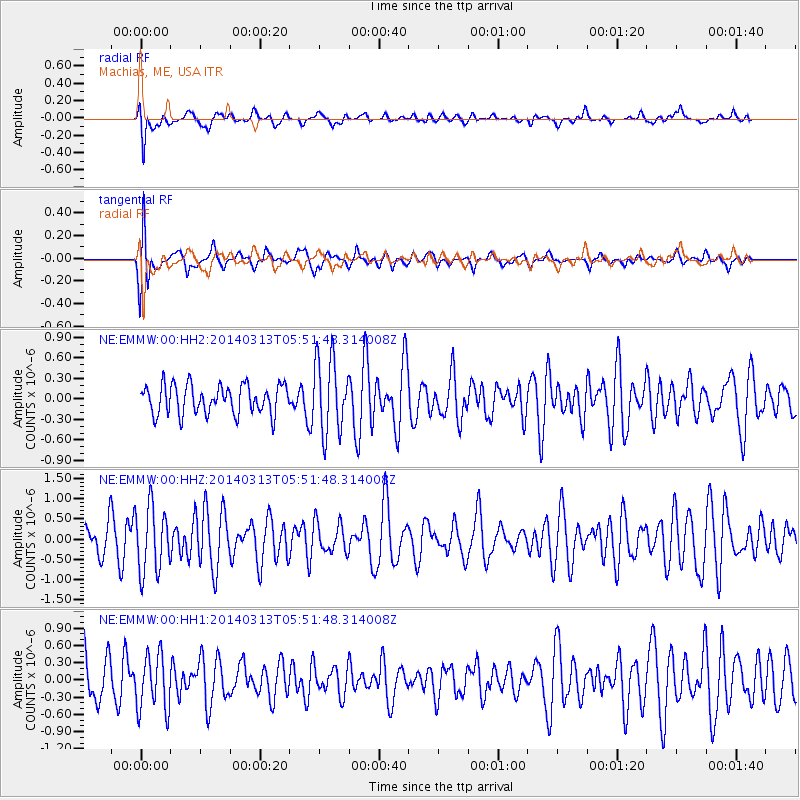
Signal To Noise
| Channel | StoN | STA | LTA |
| NE:EMMW:00:HHZ:20140313T05:51:48.314008Z | 1.9904313 | 8.0569043E-7 | 4.0478184E-7 |
| NE:EMMW:00:HH1:20140313T05:51:48.314008Z | 1.5347131 | 4.880275E-7 | 3.1799266E-7 |
| NE:EMMW:00:HH2:20140313T05:51:48.314008Z | 2.5499434 | 5.4029294E-7 | 2.1188427E-7 |
| Arrivals |
| Ps | |
| PpPs | |
| PsPs/PpSs | |


