You are here: Home > Network List > AZ - ANZA Regional Network Stations List
> Station SND AZ.SND > Earthquake Result Viewer
SND AZ.SND - Earthquake Result Viewer
| Earthquake location: |
Samoa Islands Region |
| Earthquake latitude/longitude: |
-15.6/-172.0 |
| Earthquake time(UTC): |
2009/09/29 (272) 18:08:21 GMT |
| Earthquake Depth: |
10 km |
| Earthquake Magnitude: |
5.6 MB |
| Earthquake Catalog/Contributor: |
WHDF/NEIC |
|
| Network: |
AZ ANZA Regional Network |
| Station: |
SND AZ.SND |
| Lat/Lon: |
33.55 N/116.61 W |
| Elevation: |
1358 m |
|
| Distance: |
71.9 deg |
| Az: |
46.313 deg |
| Baz: |
236.575 deg |
| Ray Param: |
0.054008383 |
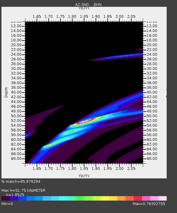
| Estimated Moho Depth: |
51.75 km |
| Estimated Crust Vp/Vs: |
1.85 |
| Assumed Crust Vp: |
6.264 km/s |
| Estimated Crust Vs: |
3.381 km/s |
| Estimated Crust Poisson's Ratio: |
0.29 |
|
| Radial Match: |
95.979294 % |
| Radial Bump: |
375 |
| Transverse Match: |
53.223434 % |
| Transverse Bump: |
356 |
| SOD ConfigId: |
2622 |
| Insert Time: |
2010-02-26 20:54:20.351 +0000 |
| GWidth: |
2.5 |
| Max Bumps: |
400 |
| Tol: |
0.001 |
|

Signal To Noise
| Channel | StoN | STA | LTA |
| AZ:SND: :BHN:20090929T18:19:14.023997Z | 1.3046377 | 4.116918E-5 | 3.1556025E-5 |
| AZ:SND: :BHE:20090929T18:19:14.023997Z | 3.1306434 | 9.91644E-5 | 3.1675405E-5 |
| AZ:SND: :BHZ:20090929T18:19:14.023997Z | 1.4320593 | 4.2259024E-5 | 2.9509267E-5 |
| Arrivals |
| Ps | 7.3 SECOND |
| PpPs | 23 SECOND |
| PsPs/PpSs | 30 SECOND |


