You are here: Home > Network List > CI - Caltech Regional Seismic Network Stations List
> Station FUR Furnace Creek, CA, USA > Earthquake Result Viewer
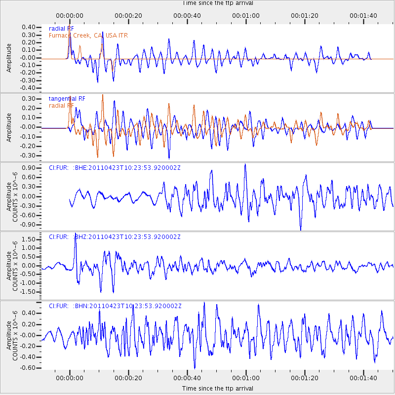
FUR Furnace Creek, CA, USA - Earthquake Result Viewer
*The percent match for this event was below the threshold and hence no stack was calculated.
| Earthquake location: |
Near East Coast Of Honshu, Japan |
| Earthquake latitude/longitude: |
39.1/142.9 |
| Earthquake time(UTC): |
2011/04/23 (113) 10:12:46 GMT |
| Earthquake Depth: |
31 km |
| Earthquake Magnitude: |
5.8 MB, 5.6 MS, 6.0 MW, 5.9 MW |
| Earthquake Catalog/Contributor: |
WHDF/NEIC |
|
| Network: |
CI Caltech Regional Seismic Network |
| Station: |
FUR Furnace Creek, CA, USA |
| Lat/Lon: |
36.47 N/116.86 W |
| Elevation: |
-37.0 m |
|
| Distance: |
74.9 deg |
| Az: |
55.227 deg |
| Baz: |
307.539 deg |
| Ray Param: |
$rayparam |
*The percent match for this event was below the threshold and hence was not used in the summary stack. |
|
| Radial Match: |
74.72329 % |
| Radial Bump: |
395 |
| Transverse Match: |
78.53283 % |
| Transverse Bump: |
400 |
| SOD ConfigId: |
356183 |
| Insert Time: |
2011-10-01 04:22:07.114 +0000 |
| GWidth: |
2.5 |
| Max Bumps: |
400 |
| Tol: |
0.001 |
|
Signal To Noise
| Channel | StoN | STA | LTA |
| CI:FUR: :BHZ:20110423T10:23:53.920002Z | 5.956531 | 6.4951655E-7 | 1.09042745E-7 |
| CI:FUR: :BHN:20110423T10:23:53.920002Z | 1.093163 | 9.4111606E-8 | 8.60911E-8 |
| CI:FUR: :BHE:20110423T10:23:53.920002Z | 1.8353941 | 2.3701782E-7 | 1.2913729E-7 |
| Arrivals |
| Ps | |
| PpPs | |
| PsPs/PpSs | |


