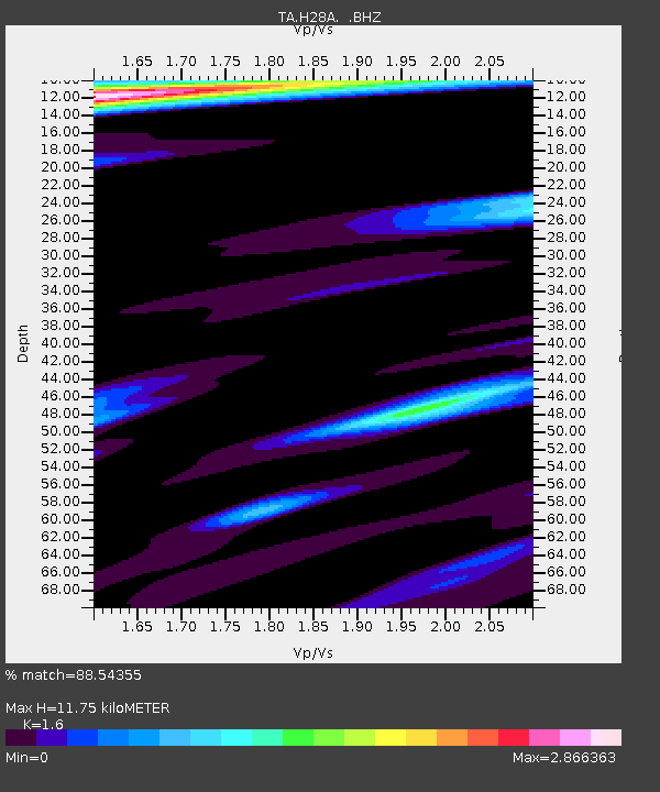
H28A Mission Ridge, SD, USA - Earthquake Result Viewer
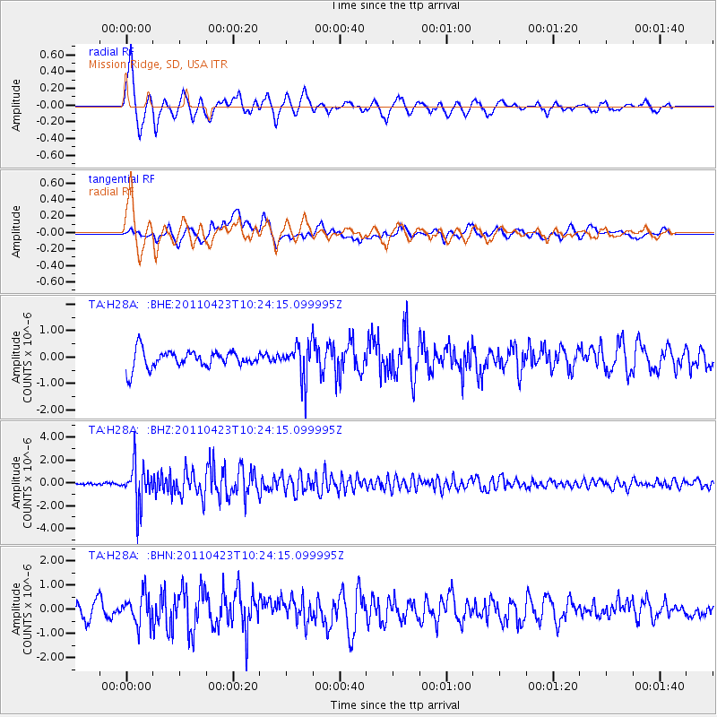
Earthquake location: Near East Coast Of Honshu, Japan
Earthquake latitude/longitude: 39.1/142.9
Earthquake time(UTC): 2011/04/23 (113) 10:12:46 GMT
Earthquake Depth: 31 km
Earthquake Magnitude: 5.8 MB, 5.6 MS, 6.0 MW, 5.9 MW
Earthquake Catalog/Contributor: WHDF/NEIC
Network: TA USArray Transportable Network (new EarthScope stations)
Station: H28A Mission Ridge, SD, USA
Lat/Lon: 44.68 N/101.02 W
Elevation: 642 m
Distance: 78.7 deg
Az: 40.791 deg
Baz: 314.559 deg
Ray Param: 0.049415335
Estimated Moho Depth: 11.75 km
Estimated Crust Vp/Vs: 1.60
Assumed Crust Vp: 6.53 km/s
Estimated Crust Vs: 4.082 km/s
Estimated Crust Poisson's Ratio: 0.18
Radial Match: 88.54355 %
Radial Bump: 400
Transverse Match: 61.110027 %
Transverse Bump: 400
SOD ConfigId: 356183
Insert Time: 2011-10-01 05:20:48.384 +0000
GWidth: 2.5
Max Bumps: 400
Tol: 0.001

Signal To Noise

ChannelStoNSTALTA
TA:H28A: :BHZ:20110423T10:24:15.099995Z13.2461831.8099206E-61.3663714E-7
TA:H28A: :BHN:20110423T10:24:15.099995Z1.81714176.246159E-73.437354E-7
TA:H28A: :BHE:20110423T10:24:15.099995Z2.09610326.790857E-73.2397534E-7
Arrivals
Ps1.1 SECOND
PpPs4.5 SECOND
PsPs/PpSs5.6 SECOND