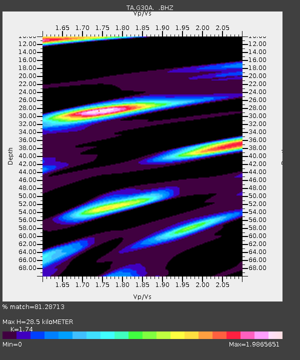
G30A Faulkton, SD, USA - Earthquake Result Viewer

Earthquake location: Near East Coast Of Honshu, Japan
Earthquake latitude/longitude: 39.1/142.9
Earthquake time(UTC): 2011/04/23 (113) 10:12:46 GMT
Earthquake Depth: 31 km
Earthquake Magnitude: 5.8 MB, 5.6 MS, 6.0 MW, 5.9 MW
Earthquake Catalog/Contributor: WHDF/NEIC
Network: TA USArray Transportable Network (new EarthScope stations)
Station: G30A Faulkton, SD, USA
Lat/Lon: 45.13 N/99.14 W
Elevation: 496 m
Distance: 79.3 deg
Az: 39.502 deg
Baz: 315.633 deg
Ray Param: 0.048993528
Estimated Moho Depth: 28.5 km
Estimated Crust Vp/Vs: 1.74
Assumed Crust Vp: 6.53 km/s
Estimated Crust Vs: 3.753 km/s
Estimated Crust Poisson's Ratio: 0.25
Radial Match: 81.28713 %
Radial Bump: 400
Transverse Match: 69.12914 %
Transverse Bump: 400
SOD ConfigId: 356183
Insert Time: 2011-10-01 05:34:33.167 +0000
GWidth: 2.5
Max Bumps: 400
Tol: 0.001

Signal To Noise

ChannelStoNSTALTA
TA:G30A: :BHZ:20110423T10:24:18.50002Z12.2612581.2737844E-61.03886926E-7
TA:G30A: :BHN:20110423T10:24:18.50002Z3.90061247.649163E-71.961016E-7
TA:G30A: :BHE:20110423T10:24:18.50002Z2.66644935.3186363E-71.994651E-7
Arrivals
Ps3.3 SECOND
PpPs12 SECOND
PsPs/PpSs15 SECOND