You are here: Home > Network List > TA - USArray Transportable Network (new EarthScope stations) Stations List
> Station 340A Bronson, TX, USA > Earthquake Result Viewer
340A Bronson, TX, USA - Earthquake Result Viewer
*The percent match for this event was below the threshold and hence no stack was calculated.
| Earthquake location: |
Near East Coast Of Honshu, Japan |
| Earthquake latitude/longitude: |
39.1/142.9 |
| Earthquake time(UTC): |
2011/04/23 (113) 10:12:46 GMT |
| Earthquake Depth: |
31 km |
| Earthquake Magnitude: |
5.8 MB, 5.6 MS, 6.0 MW, 5.9 MW |
| Earthquake Catalog/Contributor: |
WHDF/NEIC |
|
| Network: |
TA USArray Transportable Network (new EarthScope stations) |
| Station: |
340A Bronson, TX, USA |
| Lat/Lon: |
31.42 N/93.89 W |
| Elevation: |
57 m |
|
| Distance: |
92.2 deg |
| Az: |
45.693 deg |
| Baz: |
319.359 deg |
| Ray Param: |
$rayparam |
*The percent match for this event was below the threshold and hence was not used in the summary stack. |
|
| Radial Match: |
38.73094 % |
| Radial Bump: |
400 |
| Transverse Match: |
53.906002 % |
| Transverse Bump: |
400 |
| SOD ConfigId: |
356183 |
| Insert Time: |
2011-10-01 05:57:05.642 +0000 |
| GWidth: |
2.5 |
| Max Bumps: |
400 |
| Tol: |
0.001 |
|
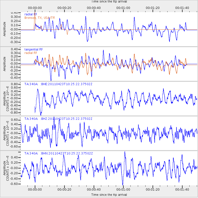
Signal To Noise
| Channel | StoN | STA | LTA |
| TA:340A: :BHZ:20110423T10:25:22.37502Z | 1.3302941 | 2.3406913E-7 | 1.7595292E-7 |
| TA:340A: :BHN:20110423T10:25:22.37502Z | 1.2638854 | 2.7132216E-7 | 2.1467308E-7 |
| TA:340A: :BHE:20110423T10:25:22.37502Z | 0.8589754 | 2.8124927E-7 | 3.2742412E-7 |
| Arrivals |
| Ps | |
| PpPs | |
| PsPs/PpSs | |


