You are here: Home > Network List > TA - USArray Transportable Network (new EarthScope stations) Stations List
> Station Z38A Mt. Pleasant, TX, USA > Earthquake Result Viewer
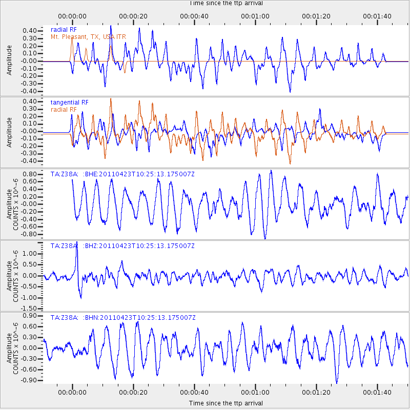
Z38A Mt. Pleasant, TX, USA - Earthquake Result Viewer
*The percent match for this event was below the threshold and hence no stack was calculated.
| Earthquake location: |
Near East Coast Of Honshu, Japan |
| Earthquake latitude/longitude: |
39.1/142.9 |
| Earthquake time(UTC): |
2011/04/23 (113) 10:12:46 GMT |
| Earthquake Depth: |
31 km |
| Earthquake Magnitude: |
5.8 MB, 5.6 MS, 6.0 MW, 5.9 MW |
| Earthquake Catalog/Contributor: |
WHDF/NEIC |
|
| Network: |
TA USArray Transportable Network (new EarthScope stations) |
| Station: |
Z38A Mt. Pleasant, TX, USA |
| Lat/Lon: |
33.25 N/94.99 W |
| Elevation: |
116 m |
|
| Distance: |
90.2 deg |
| Az: |
45.196 deg |
| Baz: |
318.786 deg |
| Ray Param: |
$rayparam |
*The percent match for this event was below the threshold and hence was not used in the summary stack. |
|
| Radial Match: |
51.08266 % |
| Radial Bump: |
347 |
| Transverse Match: |
41.37314 % |
| Transverse Bump: |
400 |
| SOD ConfigId: |
356183 |
| Insert Time: |
2011-10-01 06:03:11.513 +0000 |
| GWidth: |
2.5 |
| Max Bumps: |
400 |
| Tol: |
0.001 |
|
Signal To Noise
| Channel | StoN | STA | LTA |
| TA:Z38A: :BHZ:20110423T10:25:13.175007Z | 5.0205483 | 5.7332136E-7 | 1.1419497E-7 |
| TA:Z38A: :BHN:20110423T10:25:13.175007Z | 0.5357597 | 1.1412001E-7 | 2.1300596E-7 |
| TA:Z38A: :BHE:20110423T10:25:13.175007Z | 1.3546307 | 4.8220465E-7 | 3.5596761E-7 |
| Arrivals |
| Ps | |
| PpPs | |
| PsPs/PpSs | |


