You are here: Home > Network List > TA - USArray Transportable Network (new EarthScope stations) Stations List
> Station N34A Lincoln, NE, USA > Earthquake Result Viewer
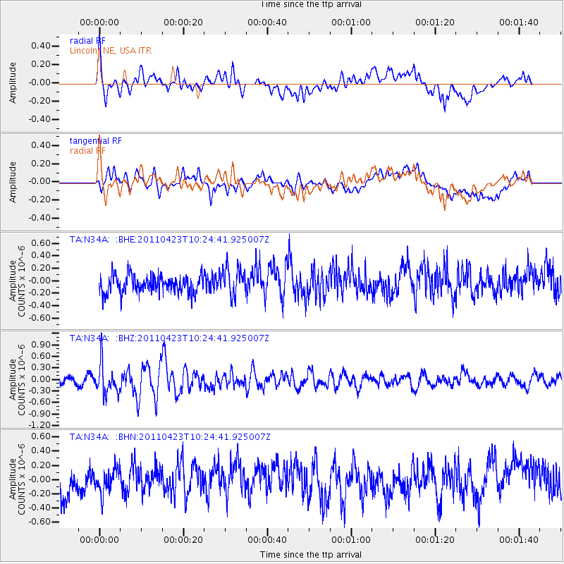
N34A Lincoln, NE, USA - Earthquake Result Viewer
*The percent match for this event was below the threshold and hence no stack was calculated.
| Earthquake location: |
Near East Coast Of Honshu, Japan |
| Earthquake latitude/longitude: |
39.1/142.9 |
| Earthquake time(UTC): |
2011/04/23 (113) 10:12:46 GMT |
| Earthquake Depth: |
31 km |
| Earthquake Magnitude: |
5.8 MB, 5.6 MS, 6.0 MW, 5.9 MW |
| Earthquake Catalog/Contributor: |
WHDF/NEIC |
|
| Network: |
TA USArray Transportable Network (new EarthScope stations) |
| Station: |
N34A Lincoln, NE, USA |
| Lat/Lon: |
40.84 N/96.50 W |
| Elevation: |
401 m |
|
| Distance: |
83.8 deg |
| Az: |
41.052 deg |
| Baz: |
317.659 deg |
| Ray Param: |
$rayparam |
*The percent match for this event was below the threshold and hence was not used in the summary stack. |
|
| Radial Match: |
57.078342 % |
| Radial Bump: |
400 |
| Transverse Match: |
54.484936 % |
| Transverse Bump: |
400 |
| SOD ConfigId: |
356183 |
| Insert Time: |
2011-10-01 06:08:20.358 +0000 |
| GWidth: |
2.5 |
| Max Bumps: |
400 |
| Tol: |
0.001 |
|
Signal To Noise
| Channel | StoN | STA | LTA |
| TA:N34A: :BHZ:20110423T10:24:41.925007Z | 2.3908763 | 4.0849474E-7 | 1.7085566E-7 |
| TA:N34A: :BHN:20110423T10:24:41.925007Z | 0.64718443 | 1.7107895E-7 | 2.6434344E-7 |
| TA:N34A: :BHE:20110423T10:24:41.925007Z | 1.7307615 | 2.3409378E-7 | 1.3525478E-7 |
| Arrivals |
| Ps | |
| PpPs | |
| PsPs/PpSs | |


