You are here: Home > Network List > TA - USArray Transportable Network (new EarthScope stations) Stations List
> Station J34A George, IA, USA > Earthquake Result Viewer
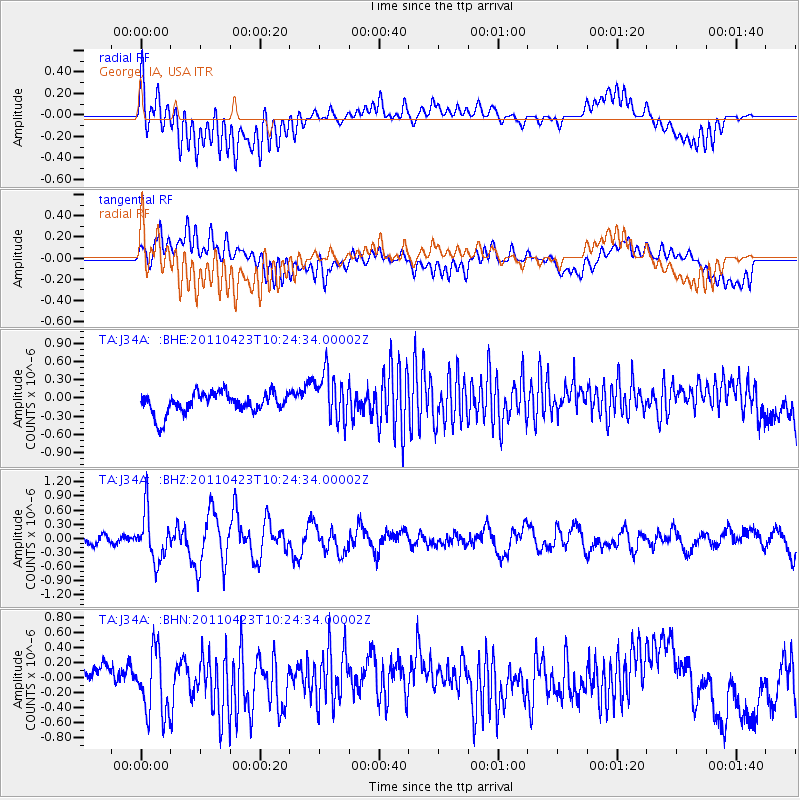
J34A George, IA, USA - Earthquake Result Viewer
*The percent match for this event was below the threshold and hence no stack was calculated.
| Earthquake location: |
Near East Coast Of Honshu, Japan |
| Earthquake latitude/longitude: |
39.1/142.9 |
| Earthquake time(UTC): |
2011/04/23 (113) 10:12:46 GMT |
| Earthquake Depth: |
31 km |
| Earthquake Magnitude: |
5.8 MB, 5.6 MS, 6.0 MW, 5.9 MW |
| Earthquake Catalog/Contributor: |
WHDF/NEIC |
|
| Network: |
TA USArray Transportable Network (new EarthScope stations) |
| Station: |
J34A George, IA, USA |
| Lat/Lon: |
43.28 N/95.96 W |
| Elevation: |
432 m |
|
| Distance: |
82.2 deg |
| Az: |
39.093 deg |
| Baz: |
317.783 deg |
| Ray Param: |
$rayparam |
*The percent match for this event was below the threshold and hence was not used in the summary stack. |
|
| Radial Match: |
64.579666 % |
| Radial Bump: |
400 |
| Transverse Match: |
60.97475 % |
| Transverse Bump: |
400 |
| SOD ConfigId: |
356183 |
| Insert Time: |
2011-10-01 06:20:57.531 +0000 |
| GWidth: |
2.5 |
| Max Bumps: |
400 |
| Tol: |
0.001 |
|
Signal To Noise
| Channel | StoN | STA | LTA |
| TA:J34A: :BHZ:20110423T10:24:34.00002Z | 3.2320385 | 5.132998E-7 | 1.5881612E-7 |
| TA:J34A: :BHN:20110423T10:24:34.00002Z | 2.3822174 | 4.3255395E-7 | 1.8157618E-7 |
| TA:J34A: :BHE:20110423T10:24:34.00002Z | 2.3033473 | 3.9590958E-7 | 1.7188445E-7 |
| Arrivals |
| Ps | |
| PpPs | |
| PsPs/PpSs | |


