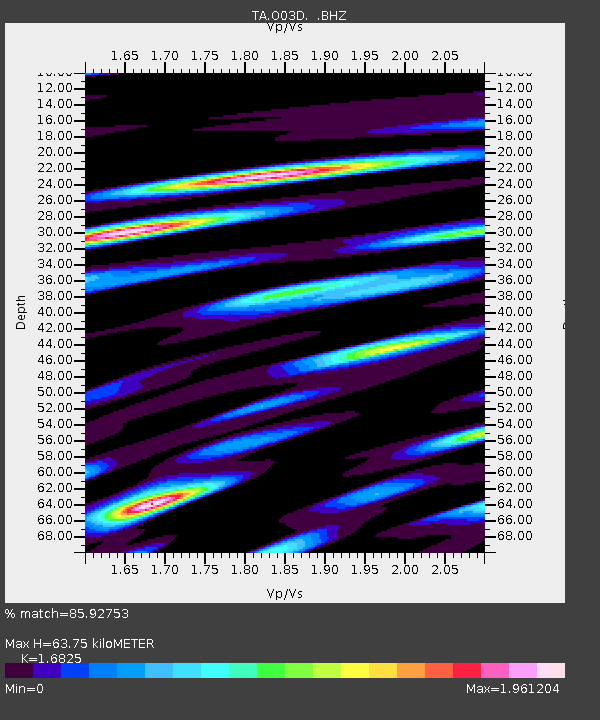
O03D Paynes Creek, CA, USA - Earthquake Result Viewer
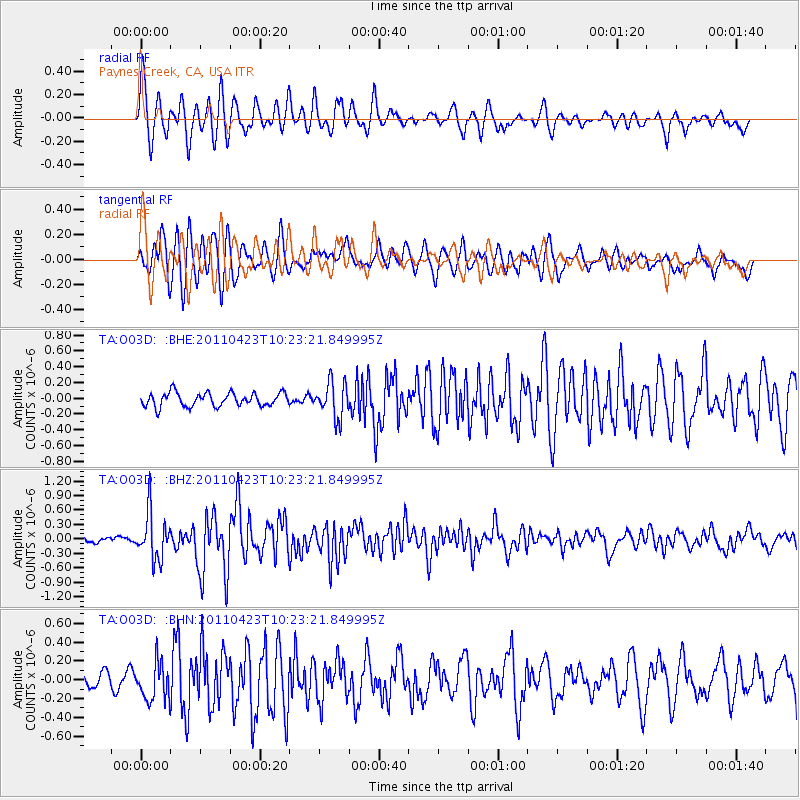
Earthquake location: Near East Coast Of Honshu, Japan
Earthquake latitude/longitude: 39.1/142.9
Earthquake time(UTC): 2011/04/23 (113) 10:12:46 GMT
Earthquake Depth: 31 km
Earthquake Magnitude: 5.8 MB, 5.6 MS, 6.0 MW, 5.9 MW
Earthquake Catalog/Contributor: WHDF/NEIC
Network: TA USArray Transportable Network (new EarthScope stations)
Station: O03D Paynes Creek, CA, USA
Lat/Lon: 40.29 N/121.80 W
Elevation: 968 m
Distance: 69.6 deg
Az: 54.367 deg
Baz: 304.22 deg
Ray Param: 0.0555248
Estimated Moho Depth: 63.75 km
Estimated Crust Vp/Vs: 1.68
Assumed Crust Vp: 6.566 km/s
Estimated Crust Vs: 3.903 km/s
Estimated Crust Poisson's Ratio: 0.23
Radial Match: 85.92753 %
Radial Bump: 400
Transverse Match: 83.46973 %
Transverse Bump: 400
SOD ConfigId: 356183
Insert Time: 2011-10-01 06:22:35.109 +0000
GWidth: 2.5
Max Bumps: 400
Tol: 0.001

Signal To Noise

ChannelStoNSTALTA
TA:O03D: :BHZ:20110423T10:23:21.849995Z7.2084854.86183E-76.744593E-8
TA:O03D: :BHN:20110423T10:23:21.849995Z1.85540061.9958573E-71.0757016E-7
TA:O03D: :BHE:20110423T10:23:21.849995Z2.5734882.2346242E-78.683251E-8
Arrivals
Ps6.9 SECOND
PpPs25 SECOND
PsPs/PpSs32 SECOND