You are here: Home > Network List > TA - USArray Transportable Network (new EarthScope stations) Stations List
> Station D31A Mcclaflin, Tower City, ND, USA > Earthquake Result Viewer
D31A Mcclaflin, Tower City, ND, USA - Earthquake Result Viewer

| Earthquake location: |
Near East Coast Of Honshu, Japan |
| Earthquake latitude/longitude: |
39.1/142.9 |
| Earthquake time(UTC): |
2011/04/23 (113) 10:12:46 GMT |
| Earthquake Depth: |
31 km |
| Earthquake Magnitude: |
5.8 MB, 5.6 MS, 6.0 MW, 5.9 MW |
| Earthquake Catalog/Contributor: |
WHDF/NEIC |
|
| Network: |
TA USArray Transportable Network (new EarthScope stations) |
| Station: |
D31A Mcclaflin, Tower City, ND, USA |
| Lat/Lon: |
47.05 N/97.72 W |
| Elevation: |
359 m |
|
| Distance: |
78.6 deg |
| Az: |
37.418 deg |
| Baz: |
316.256 deg |
| Ray Param: |
0.049463693 |
| Estimated Moho Depth: |
43.5 km |
| Estimated Crust Vp/Vs: |
1.62 |
| Assumed Crust Vp: |
6.498 km/s |
| Estimated Crust Vs: |
3.998 km/s |
| Estimated Crust Poisson's Ratio: |
0.20 |
|
| Radial Match: |
85.26617 % |
| Radial Bump: |
400 |
| Transverse Match: |
60.338737 % |
| Transverse Bump: |
400 |
| SOD ConfigId: |
356183 |
| Insert Time: |
2011-10-01 06:23:15.452 +0000 |
| GWidth: |
2.5 |
| Max Bumps: |
400 |
| Tol: |
0.001 |
|
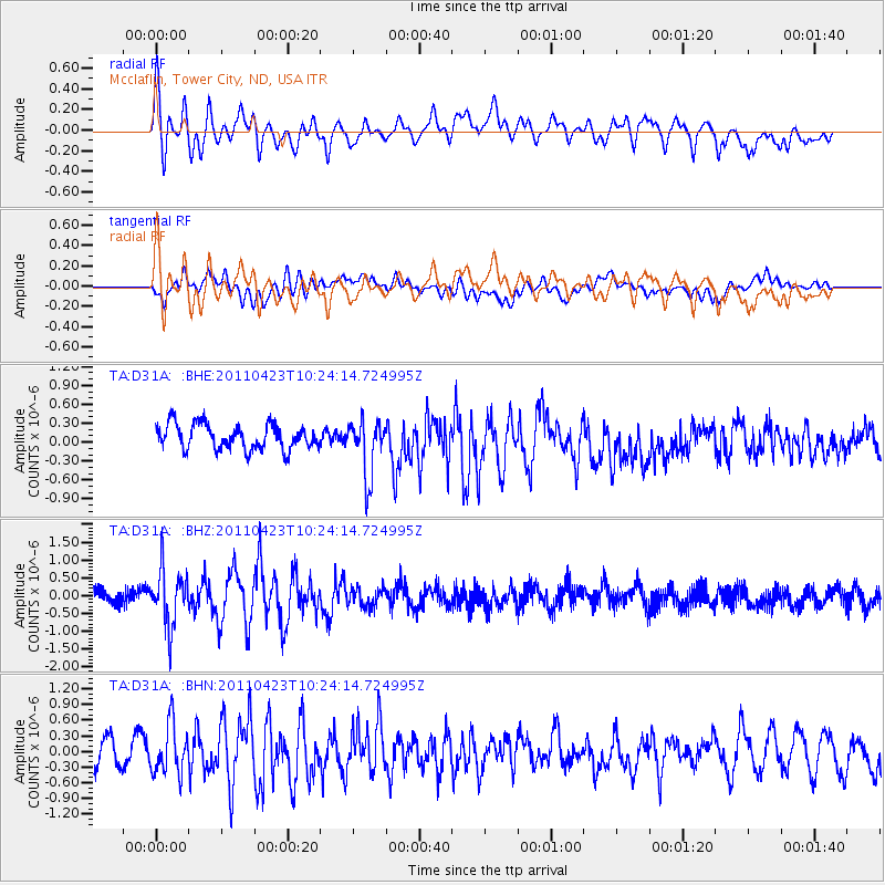
Signal To Noise
| Channel | StoN | STA | LTA |
| TA:D31A: :BHZ:20110423T10:24:14.724995Z | 3.874531 | 7.875337E-7 | 2.0325909E-7 |
| TA:D31A: :BHN:20110423T10:24:14.724995Z | 2.0892966 | 4.7989937E-7 | 2.2969424E-7 |
| TA:D31A: :BHE:20110423T10:24:14.724995Z | 2.2396653 | 4.4399715E-7 | 1.9824263E-7 |
| Arrivals |
| Ps | 4.3 SECOND |
| PpPs | 17 SECOND |
| PsPs/PpSs | 21 SECOND |


