You are here: Home > Network List > TA - USArray Transportable Network (new EarthScope stations) Stations List
> Station D37A Cotton, MN, USA > Earthquake Result Viewer
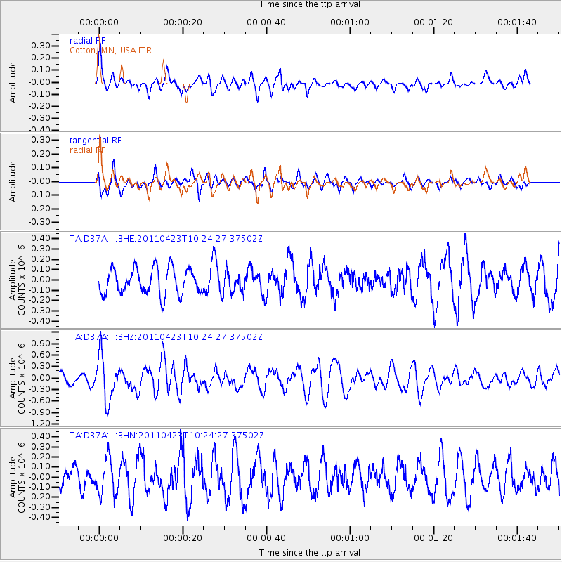
D37A Cotton, MN, USA - Earthquake Result Viewer
*The percent match for this event was below the threshold and hence no stack was calculated.
| Earthquake location: |
Near East Coast Of Honshu, Japan |
| Earthquake latitude/longitude: |
39.1/142.9 |
| Earthquake time(UTC): |
2011/04/23 (113) 10:12:46 GMT |
| Earthquake Depth: |
31 km |
| Earthquake Magnitude: |
5.8 MB, 5.6 MS, 6.0 MW, 5.9 MW |
| Earthquake Catalog/Contributor: |
WHDF/NEIC |
|
| Network: |
TA USArray Transportable Network (new EarthScope stations) |
| Station: |
D37A Cotton, MN, USA |
| Lat/Lon: |
47.16 N/92.43 W |
| Elevation: |
413 m |
|
| Distance: |
81.0 deg |
| Az: |
34.615 deg |
| Baz: |
319.629 deg |
| Ray Param: |
$rayparam |
*The percent match for this event was below the threshold and hence was not used in the summary stack. |
|
| Radial Match: |
55.417984 % |
| Radial Bump: |
388 |
| Transverse Match: |
64.27563 % |
| Transverse Bump: |
400 |
| SOD ConfigId: |
356183 |
| Insert Time: |
2011-10-01 06:31:34.924 +0000 |
| GWidth: |
2.5 |
| Max Bumps: |
400 |
| Tol: |
0.001 |
|
Signal To Noise
| Channel | StoN | STA | LTA |
| TA:D37A: :BHZ:20110423T10:24:27.37502Z | 3.3232386 | 5.794594E-7 | 1.7436588E-7 |
| TA:D37A: :BHN:20110423T10:24:27.37502Z | 1.7447059 | 1.7032222E-7 | 9.762231E-8 |
| TA:D37A: :BHE:20110423T10:24:27.37502Z | 0.85170543 | 1.05216E-7 | 1.2353567E-7 |
| Arrivals |
| Ps | |
| PpPs | |
| PsPs/PpSs | |


