You are here: Home > Network List > TA - USArray Transportable Network (new EarthScope stations) Stations List
> Station G32A Webster, SD, USA > Earthquake Result Viewer
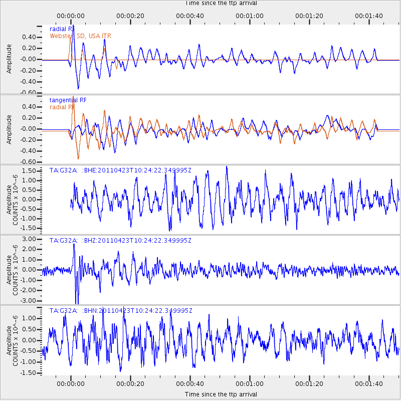
G32A Webster, SD, USA - Earthquake Result Viewer
*The percent match for this event was below the threshold and hence no stack was calculated.
| Earthquake location: |
Near East Coast Of Honshu, Japan |
| Earthquake latitude/longitude: |
39.1/142.9 |
| Earthquake time(UTC): |
2011/04/23 (113) 10:12:46 GMT |
| Earthquake Depth: |
31 km |
| Earthquake Magnitude: |
5.8 MB, 5.6 MS, 6.0 MW, 5.9 MW |
| Earthquake Catalog/Contributor: |
WHDF/NEIC |
|
| Network: |
TA USArray Transportable Network (new EarthScope stations) |
| Station: |
G32A Webster, SD, USA |
| Lat/Lon: |
45.26 N/97.50 W |
| Elevation: |
566 m |
|
| Distance: |
80.0 deg |
| Az: |
38.561 deg |
| Baz: |
316.628 deg |
| Ray Param: |
$rayparam |
*The percent match for this event was below the threshold and hence was not used in the summary stack. |
|
| Radial Match: |
66.8919 % |
| Radial Bump: |
400 |
| Transverse Match: |
65.899635 % |
| Transverse Bump: |
400 |
| SOD ConfigId: |
356183 |
| Insert Time: |
2011-10-01 06:32:17.052 +0000 |
| GWidth: |
2.5 |
| Max Bumps: |
400 |
| Tol: |
0.001 |
|
Signal To Noise
| Channel | StoN | STA | LTA |
| TA:G32A: :BHZ:20110423T10:24:22.349995Z | 5.312131 | 1.2936212E-6 | 2.4352207E-7 |
| TA:G32A: :BHN:20110423T10:24:22.349995Z | 1.0542408 | 6.102656E-7 | 5.7886734E-7 |
| TA:G32A: :BHE:20110423T10:24:22.349995Z | 1.5218396 | 7.839593E-7 | 5.151392E-7 |
| Arrivals |
| Ps | |
| PpPs | |
| PsPs/PpSs | |


