You are here: Home > Network List > TA - USArray Transportable Network (new EarthScope stations) Stations List
> Station Y42A Garnett, Star City, AR, USA > Earthquake Result Viewer
Y42A Garnett, Star City, AR, USA - Earthquake Result Viewer
*The percent match for this event was below the threshold and hence no stack was calculated.
| Earthquake location: |
Near East Coast Of Honshu, Japan |
| Earthquake latitude/longitude: |
39.1/142.9 |
| Earthquake time(UTC): |
2011/04/23 (113) 10:12:46 GMT |
| Earthquake Depth: |
31 km |
| Earthquake Magnitude: |
5.8 MB, 5.6 MS, 6.0 MW, 5.9 MW |
| Earthquake Catalog/Contributor: |
WHDF/NEIC |
|
| Network: |
TA USArray Transportable Network (new EarthScope stations) |
| Station: |
Y42A Garnett, Star City, AR, USA |
| Lat/Lon: |
33.84 N/91.79 W |
| Elevation: |
77 m |
|
| Distance: |
91.5 deg |
| Az: |
42.781 deg |
| Baz: |
320.583 deg |
| Ray Param: |
$rayparam |
*The percent match for this event was below the threshold and hence was not used in the summary stack. |
|
| Radial Match: |
63.0037 % |
| Radial Bump: |
400 |
| Transverse Match: |
62.09575 % |
| Transverse Bump: |
400 |
| SOD ConfigId: |
356183 |
| Insert Time: |
2011-10-01 07:00:40.829 +0000 |
| GWidth: |
2.5 |
| Max Bumps: |
400 |
| Tol: |
0.001 |
|
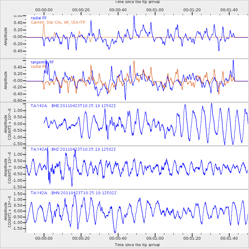
Signal To Noise
| Channel | StoN | STA | LTA |
| TA:Y42A: :BHZ:20110423T10:25:19.12502Z | 2.0218892 | 5.3844565E-7 | 2.6630818E-7 |
| TA:Y42A: :BHN:20110423T10:25:19.12502Z | 1.1323981 | 5.692262E-7 | 5.026732E-7 |
| TA:Y42A: :BHE:20110423T10:25:19.12502Z | 1.3387245 | 5.327269E-7 | 3.979362E-7 |
| Arrivals |
| Ps | |
| PpPs | |
| PsPs/PpSs | |


