You are here: Home > Network List > US - United States National Seismic Network Stations List
> Station MIAR Mount Ida, Arkansas, USA > Earthquake Result Viewer
MIAR Mount Ida, Arkansas, USA - Earthquake Result Viewer
*The percent match for this event was below the threshold and hence no stack was calculated.
| Earthquake location: |
Near East Coast Of Honshu, Japan |
| Earthquake latitude/longitude: |
39.1/142.9 |
| Earthquake time(UTC): |
2011/04/23 (113) 10:12:46 GMT |
| Earthquake Depth: |
31 km |
| Earthquake Magnitude: |
5.8 MB, 5.6 MS, 6.0 MW, 5.9 MW |
| Earthquake Catalog/Contributor: |
WHDF/NEIC |
|
| Network: |
US United States National Seismic Network |
| Station: |
MIAR Mount Ida, Arkansas, USA |
| Lat/Lon: |
34.55 N/93.58 W |
| Elevation: |
207 m |
|
| Distance: |
90.0 deg |
| Az: |
43.465 deg |
| Baz: |
319.573 deg |
| Ray Param: |
$rayparam |
*The percent match for this event was below the threshold and hence was not used in the summary stack. |
|
| Radial Match: |
62.9135 % |
| Radial Bump: |
400 |
| Transverse Match: |
29.155489 % |
| Transverse Bump: |
400 |
| SOD ConfigId: |
356183 |
| Insert Time: |
2011-10-01 07:05:42.688 +0000 |
| GWidth: |
2.5 |
| Max Bumps: |
400 |
| Tol: |
0.001 |
|
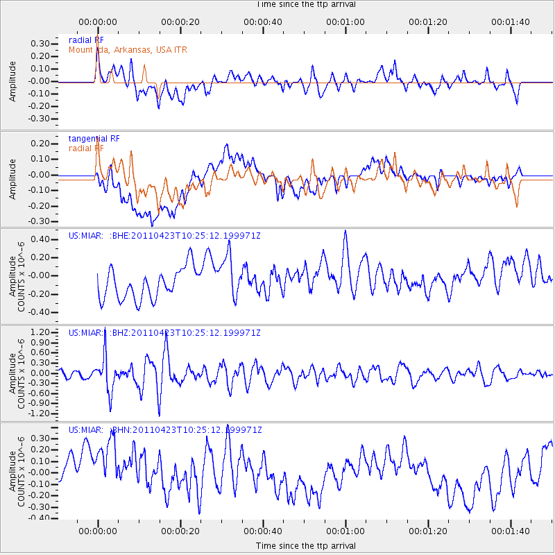
Signal To Noise
| Channel | StoN | STA | LTA |
| US:MIAR: :BHZ:20110423T10:25:12.199971Z | 4.115323 | 5.264859E-7 | 1.2793306E-7 |
| US:MIAR: :BHN:20110423T10:25:12.199971Z | 2.2467203 | 3.9518503E-7 | 1.7589417E-7 |
| US:MIAR: :BHE:20110423T10:25:12.199971Z | 1.4580561 | 2.4081567E-7 | 1.6516213E-7 |
| Arrivals |
| Ps | |
| PpPs | |
| PsPs/PpSs | |


