You are here: Home > Network List > AZ - ANZA Regional Network Stations List
> Station SND AZ.SND > Earthquake Result Viewer
SND AZ.SND - Earthquake Result Viewer
| Earthquake location: |
Tonga Islands |
| Earthquake latitude/longitude: |
-17.2/-173.9 |
| Earthquake time(UTC): |
2000/09/26 (270) 06:17:52 GMT |
| Earthquake Depth: |
56 km |
| Earthquake Magnitude: |
6.1 MB, 6.1 MS, 6.4 MW, 6.1 ME |
| Earthquake Catalog/Contributor: |
WHDF/NEIC |
|
| Network: |
AZ ANZA Regional Network |
| Station: |
SND AZ.SND |
| Lat/Lon: |
33.55 N/116.61 W |
| Elevation: |
1358 m |
|
| Distance: |
74.4 deg |
| Az: |
46.876 deg |
| Baz: |
236.669 deg |
| Ray Param: |
0.05227536 |
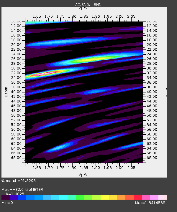
| Estimated Moho Depth: |
32.0 km |
| Estimated Crust Vp/Vs: |
1.68 |
| Assumed Crust Vp: |
6.264 km/s |
| Estimated Crust Vs: |
3.723 km/s |
| Estimated Crust Poisson's Ratio: |
0.23 |
|
| Radial Match: |
91.3203 % |
| Radial Bump: |
400 |
| Transverse Match: |
87.122795 % |
| Transverse Bump: |
400 |
| SOD ConfigId: |
3744 |
| Insert Time: |
2010-02-26 20:55:40.273 +0000 |
| GWidth: |
2.5 |
| Max Bumps: |
400 |
| Tol: |
0.001 |
|

Signal To Noise
| Channel | StoN | STA | LTA |
| AZ:SND: :BHN:20000926T06:28:53.199001Z | 2.4891481 | 3.8681475E-7 | 1.5540046E-7 |
| AZ:SND: :BHE:20000926T06:28:53.199001Z | 4.5674605 | 5.931614E-7 | 1.2986678E-7 |
| AZ:SND: :BHZ:20000926T06:28:53.199001Z | 21.082943 | 1.8788134E-6 | 8.9115325E-8 |
| Arrivals |
| Ps | 3.6 SECOND |
| PpPs | 13 SECOND |
| PsPs/PpSs | 17 SECOND |


