You are here: Home > Network List > PS - Pacific21 Stations List
> Station PSI Parapat, Indonesia > Earthquake Result Viewer
PSI Parapat, Indonesia - Earthquake Result Viewer

| Earthquake location: |
Kyushu, Japan |
| Earthquake latitude/longitude: |
33.7/131.8 |
| Earthquake time(UTC): |
2014/03/13 (072) 17:06:50 GMT |
| Earthquake Depth: |
79 km |
| Earthquake Magnitude: |
6.3 MWW, 6.3 MWB, 6.3 MWC |
| Earthquake Catalog/Contributor: |
NEIC PDE/NEIC COMCAT |
|
| Network: |
PS Pacific21 |
| Station: |
PSI Parapat, Indonesia |
| Lat/Lon: |
2.69 N/98.92 E |
| Elevation: |
987 m |
|
| Distance: |
43.5 deg |
| Az: |
231.991 deg |
| Baz: |
41.124 deg |
| Ray Param: |
0.07223397 |
| Estimated Moho Depth: |
22.75 km |
| Estimated Crust Vp/Vs: |
2.10 |
| Assumed Crust Vp: |
6.468 km/s |
| Estimated Crust Vs: |
3.084 km/s |
| Estimated Crust Poisson's Ratio: |
0.35 |
|
| Radial Match: |
93.71927 % |
| Radial Bump: |
390 |
| Transverse Match: |
79.20782 % |
| Transverse Bump: |
400 |
| SOD ConfigId: |
3390531 |
| Insert Time: |
2019-04-10 15:35:26.403 +0000 |
| GWidth: |
2.5 |
| Max Bumps: |
400 |
| Tol: |
0.001 |
|
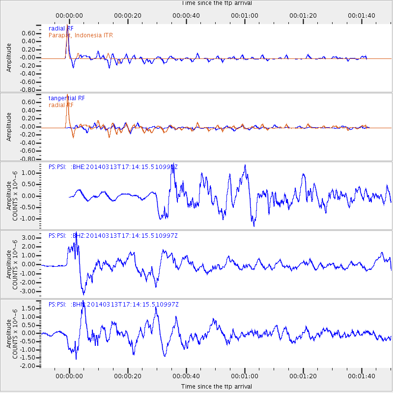
Signal To Noise
| Channel | StoN | STA | LTA |
| PS:PSI: :BHZ:20140313T17:14:15.510997Z | 22.036911 | 2.0041477E-6 | 9.0945036E-8 |
| PS:PSI: :BHN:20140313T17:14:15.510997Z | 10.896459 | 9.969841E-7 | 9.1496155E-8 |
| PS:PSI: :BHE:20140313T17:14:15.510997Z | 6.6794915 | 8.012781E-7 | 1.1996094E-7 |
| Arrivals |
| Ps | 4.1 SECOND |
| PpPs | 10 SECOND |
| PsPs/PpSs | 14 SECOND |


