You are here: Home > Network List > US - United States National Seismic Network Stations List
> Station HAWA Hanford, Washington, USA > Earthquake Result Viewer
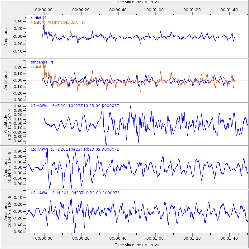
HAWA Hanford, Washington, USA - Earthquake Result Viewer
*The percent match for this event was below the threshold and hence no stack was calculated.
| Earthquake location: |
Near East Coast Of Honshu, Japan |
| Earthquake latitude/longitude: |
39.1/142.9 |
| Earthquake time(UTC): |
2011/04/23 (113) 10:12:46 GMT |
| Earthquake Depth: |
31 km |
| Earthquake Magnitude: |
5.8 MB, 5.6 MS, 6.0 MW, 5.9 MW |
| Earthquake Catalog/Contributor: |
WHDF/NEIC |
|
| Network: |
US United States National Seismic Network |
| Station: |
HAWA Hanford, Washington, USA |
| Lat/Lon: |
46.39 N/119.53 W |
| Elevation: |
364 m |
|
| Distance: |
67.5 deg |
| Az: |
47.936 deg |
| Baz: |
303.42 deg |
| Ray Param: |
$rayparam |
*The percent match for this event was below the threshold and hence was not used in the summary stack. |
|
| Radial Match: |
75.30293 % |
| Radial Bump: |
400 |
| Transverse Match: |
68.10851 % |
| Transverse Bump: |
400 |
| SOD ConfigId: |
356183 |
| Insert Time: |
2011-10-01 07:11:04.323 +0000 |
| GWidth: |
2.5 |
| Max Bumps: |
400 |
| Tol: |
0.001 |
|
Signal To Noise
| Channel | StoN | STA | LTA |
| US:HAWA: :BHZ:20110423T10:23:09.300007Z | 5.0019464 | 5.784205E-7 | 1.1563909E-7 |
| US:HAWA: :BHN:20110423T10:23:09.300007Z | 2.3445635 | 1.635417E-7 | 6.975358E-8 |
| US:HAWA: :BHE:20110423T10:23:09.300007Z | 2.7170017 | 2.5399825E-7 | 9.3484765E-8 |
| Arrivals |
| Ps | |
| PpPs | |
| PsPs/PpSs | |


