You are here: Home > Network List > US - United States National Seismic Network Stations List
> Station AMTX Amarillo, Texas, USA > Earthquake Result Viewer
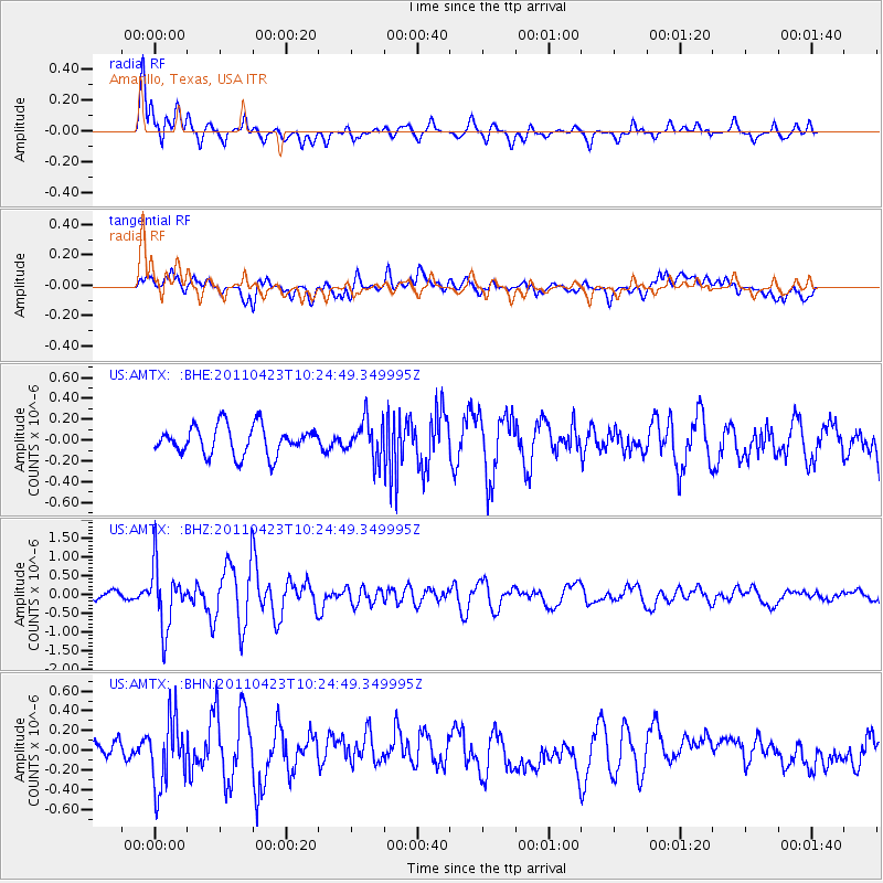
AMTX Amarillo, Texas, USA - Earthquake Result Viewer
*The percent match for this event was below the threshold and hence no stack was calculated.
| Earthquake location: |
Near East Coast Of Honshu, Japan |
| Earthquake latitude/longitude: |
39.1/142.9 |
| Earthquake time(UTC): |
2011/04/23 (113) 10:12:46 GMT |
| Earthquake Depth: |
31 km |
| Earthquake Magnitude: |
5.8 MB, 5.6 MS, 6.0 MW, 5.9 MW |
| Earthquake Catalog/Contributor: |
WHDF/NEIC |
|
| Network: |
US United States National Seismic Network |
| Station: |
AMTX Amarillo, Texas, USA |
| Lat/Lon: |
34.53 N/101.41 W |
| Elevation: |
1010 m |
|
| Distance: |
85.7 deg |
| Az: |
48.239 deg |
| Baz: |
315.327 deg |
| Ray Param: |
$rayparam |
*The percent match for this event was below the threshold and hence was not used in the summary stack. |
|
| Radial Match: |
72.416145 % |
| Radial Bump: |
400 |
| Transverse Match: |
64.92491 % |
| Transverse Bump: |
400 |
| SOD ConfigId: |
356183 |
| Insert Time: |
2011-10-01 07:14:14.874 +0000 |
| GWidth: |
2.5 |
| Max Bumps: |
400 |
| Tol: |
0.001 |
|
Signal To Noise
| Channel | StoN | STA | LTA |
| US:AMTX: :BHZ:20110423T10:24:49.349995Z | 9.057775 | 8.1519977E-7 | 9.000001E-8 |
| US:AMTX: :BHN:20110423T10:24:49.349995Z | 2.663212 | 3.3957846E-7 | 1.275071E-7 |
| US:AMTX: :BHE:20110423T10:24:49.349995Z | 1.9587837 | 2.7216706E-7 | 1.3894697E-7 |
| Arrivals |
| Ps | |
| PpPs | |
| PsPs/PpSs | |


