You are here: Home > Network List > TA - USArray Transportable Network (new EarthScope stations) Stations List
> Station C26A Wahner Farm, Parshall, ND, USA > Earthquake Result Viewer
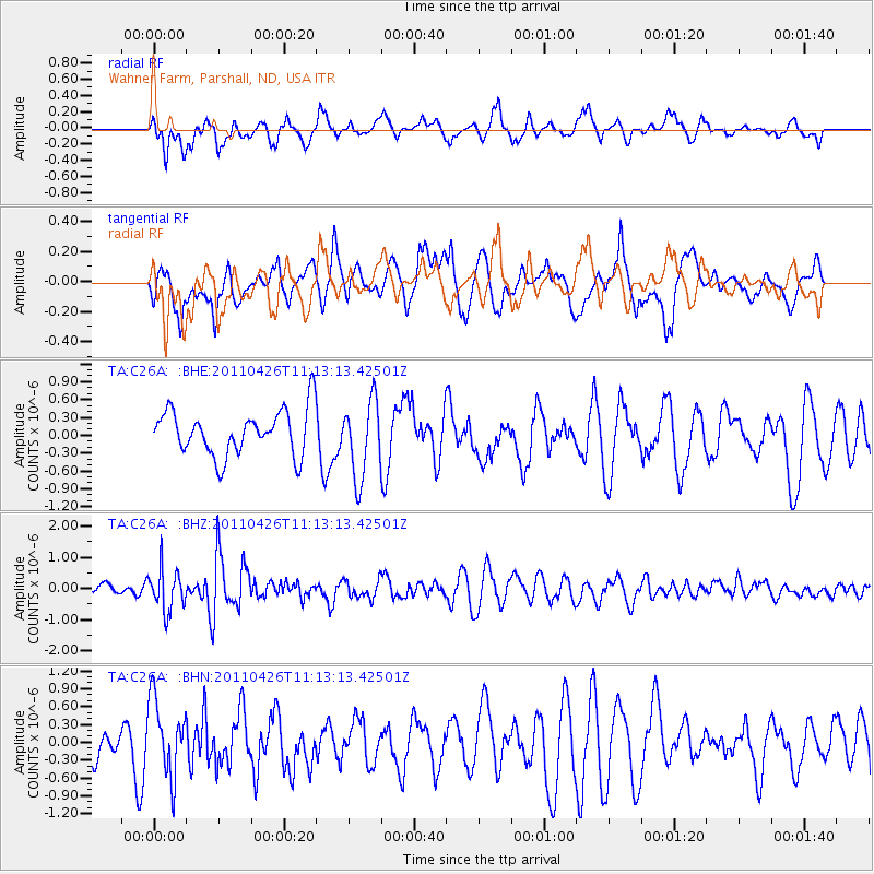
C26A Wahner Farm, Parshall, ND, USA - Earthquake Result Viewer
*The percent match for this event was below the threshold and hence no stack was calculated.
| Earthquake location: |
Near Coast Of Guerrero, Mexico |
| Earthquake latitude/longitude: |
16.9/-99.5 |
| Earthquake time(UTC): |
2011/04/26 (116) 11:07:27 GMT |
| Earthquake Depth: |
11 km |
| Earthquake Magnitude: |
5.5 MW, 4.9 MS, 5.3 MB, 5.4 MW |
| Earthquake Catalog/Contributor: |
WHDF/NEIC |
|
| Network: |
TA USArray Transportable Network (new EarthScope stations) |
| Station: |
C26A Wahner Farm, Parshall, ND, USA |
| Lat/Lon: |
47.83 N/102.10 W |
| Elevation: |
656 m |
|
| Distance: |
31.0 deg |
| Az: |
356.562 deg |
| Baz: |
175.111 deg |
| Ray Param: |
$rayparam |
*The percent match for this event was below the threshold and hence was not used in the summary stack. |
|
| Radial Match: |
59.96561 % |
| Radial Bump: |
400 |
| Transverse Match: |
51.19892 % |
| Transverse Bump: |
400 |
| SOD ConfigId: |
356183 |
| Insert Time: |
2011-10-01 08:40:08.429 +0000 |
| GWidth: |
2.5 |
| Max Bumps: |
400 |
| Tol: |
0.001 |
|
Signal To Noise
| Channel | StoN | STA | LTA |
| TA:C26A: :BHZ:20110426T11:13:13.42501Z | 3.3924518 | 6.6605025E-7 | 1.9633302E-7 |
| TA:C26A: :BHN:20110426T11:13:13.42501Z | 1.9308836 | 6.429457E-7 | 3.3298002E-7 |
| TA:C26A: :BHE:20110426T11:13:13.42501Z | 1.713069 | 6.533403E-7 | 3.8138586E-7 |
| Arrivals |
| Ps | |
| PpPs | |
| PsPs/PpSs | |


