You are here: Home > Network List > TA - USArray Transportable Network (new EarthScope stations) Stations List
> Station B27A Peters Farms, Glenburn, ND, USA > Earthquake Result Viewer
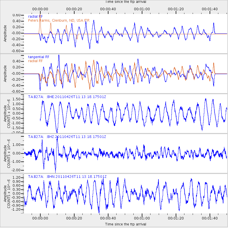
B27A Peters Farms, Glenburn, ND, USA - Earthquake Result Viewer
*The percent match for this event was below the threshold and hence no stack was calculated.
| Earthquake location: |
Near Coast Of Guerrero, Mexico |
| Earthquake latitude/longitude: |
16.9/-99.5 |
| Earthquake time(UTC): |
2011/04/26 (116) 11:07:27 GMT |
| Earthquake Depth: |
11 km |
| Earthquake Magnitude: |
5.5 MW, 4.9 MS, 5.3 MB, 5.4 MW |
| Earthquake Catalog/Contributor: |
WHDF/NEIC |
|
| Network: |
TA USArray Transportable Network (new EarthScope stations) |
| Station: |
B27A Peters Farms, Glenburn, ND, USA |
| Lat/Lon: |
48.40 N/101.26 W |
| Elevation: |
492 m |
|
| Distance: |
31.5 deg |
| Az: |
357.718 deg |
| Baz: |
176.72 deg |
| Ray Param: |
$rayparam |
*The percent match for this event was below the threshold and hence was not used in the summary stack. |
|
| Radial Match: |
59.2612 % |
| Radial Bump: |
400 |
| Transverse Match: |
54.90301 % |
| Transverse Bump: |
400 |
| SOD ConfigId: |
356183 |
| Insert Time: |
2011-10-01 08:42:14.640 +0000 |
| GWidth: |
2.5 |
| Max Bumps: |
400 |
| Tol: |
0.001 |
|
Signal To Noise
| Channel | StoN | STA | LTA |
| TA:B27A: :BHZ:20110426T11:13:18.17501Z | 3.8001006 | 7.370512E-7 | 1.9395571E-7 |
| TA:B27A: :BHN:20110426T11:13:18.17501Z | 1.2352631 | 4.881976E-7 | 3.9521748E-7 |
| TA:B27A: :BHE:20110426T11:13:18.17501Z | 0.8984559 | 7.189401E-7 | 8.0019515E-7 |
| Arrivals |
| Ps | |
| PpPs | |
| PsPs/PpSs | |


