You are here: Home > Network List > TA - USArray Transportable Network (new EarthScope stations) Stations List
> Station D30A Buchanan, ND, USA > Earthquake Result Viewer
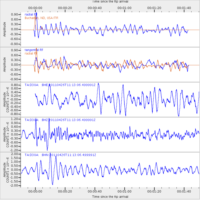
D30A Buchanan, ND, USA - Earthquake Result Viewer
*The percent match for this event was below the threshold and hence no stack was calculated.
| Earthquake location: |
Near Coast Of Guerrero, Mexico |
| Earthquake latitude/longitude: |
16.9/-99.5 |
| Earthquake time(UTC): |
2011/04/26 (116) 11:07:27 GMT |
| Earthquake Depth: |
11 km |
| Earthquake Magnitude: |
5.5 MW, 4.9 MS, 5.3 MB, 5.4 MW |
| Earthquake Catalog/Contributor: |
WHDF/NEIC |
|
| Network: |
TA USArray Transportable Network (new EarthScope stations) |
| Station: |
D30A Buchanan, ND, USA |
| Lat/Lon: |
47.11 N/98.76 W |
| Elevation: |
465 m |
|
| Distance: |
30.2 deg |
| Az: |
0.969 deg |
| Baz: |
181.359 deg |
| Ray Param: |
$rayparam |
*The percent match for this event was below the threshold and hence was not used in the summary stack. |
|
| Radial Match: |
49.227943 % |
| Radial Bump: |
400 |
| Transverse Match: |
53.66594 % |
| Transverse Bump: |
400 |
| SOD ConfigId: |
356183 |
| Insert Time: |
2011-10-01 08:43:45.284 +0000 |
| GWidth: |
2.5 |
| Max Bumps: |
400 |
| Tol: |
0.001 |
|
Signal To Noise
| Channel | StoN | STA | LTA |
| TA:D30A: :BHZ:20110426T11:13:06.499991Z | 3.3788974 | 4.7886823E-7 | 1.4172322E-7 |
| TA:D30A: :BHN:20110426T11:13:06.499991Z | 1.6712481 | 7.251524E-7 | 4.3389872E-7 |
| TA:D30A: :BHE:20110426T11:13:06.499991Z | 0.74801224 | 2.162766E-7 | 2.891351E-7 |
| Arrivals |
| Ps | |
| PpPs | |
| PsPs/PpSs | |


