You are here: Home > Network List > US - United States National Seismic Network Stations List
> Station LONY Lake Ozonia, New York, USA > Earthquake Result Viewer
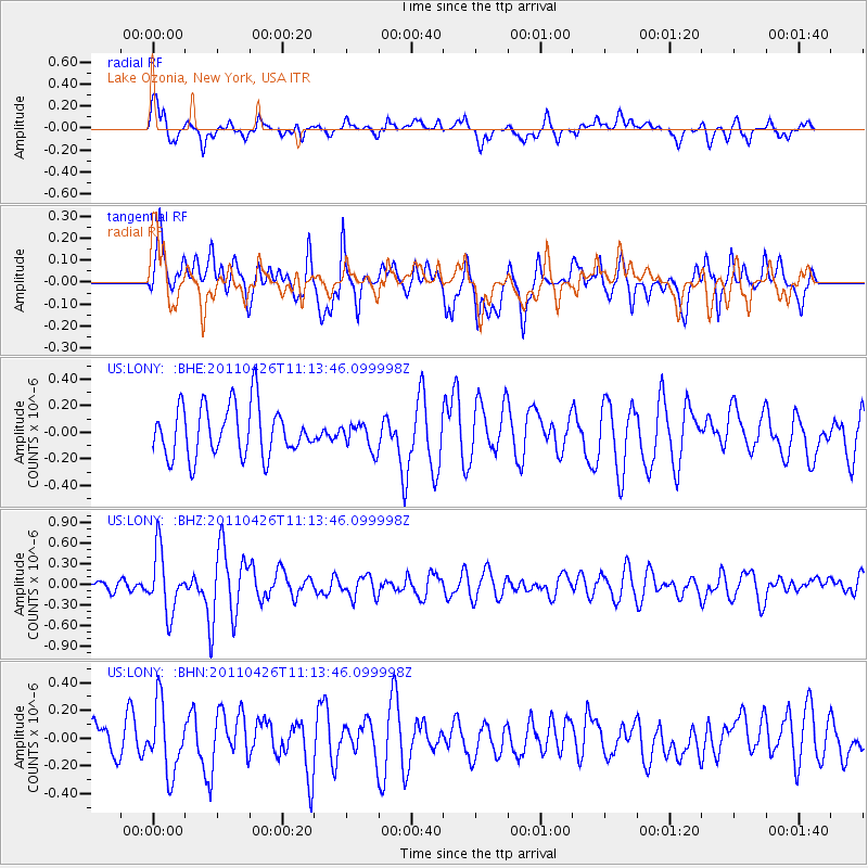
LONY Lake Ozonia, New York, USA - Earthquake Result Viewer
*The percent match for this event was below the threshold and hence no stack was calculated.
| Earthquake location: |
Near Coast Of Guerrero, Mexico |
| Earthquake latitude/longitude: |
16.9/-99.5 |
| Earthquake time(UTC): |
2011/04/26 (116) 11:07:27 GMT |
| Earthquake Depth: |
11 km |
| Earthquake Magnitude: |
5.5 MW, 4.9 MS, 5.3 MB, 5.4 MW |
| Earthquake Catalog/Contributor: |
WHDF/NEIC |
|
| Network: |
US United States National Seismic Network |
| Station: |
LONY Lake Ozonia, New York, USA |
| Lat/Lon: |
44.62 N/74.58 W |
| Elevation: |
440 m |
|
| Distance: |
34.7 deg |
| Az: |
31.855 deg |
| Baz: |
225.048 deg |
| Ray Param: |
$rayparam |
*The percent match for this event was below the threshold and hence was not used in the summary stack. |
|
| Radial Match: |
65.879776 % |
| Radial Bump: |
400 |
| Transverse Match: |
62.366535 % |
| Transverse Bump: |
400 |
| SOD ConfigId: |
356183 |
| Insert Time: |
2011-10-01 08:56:22.575 +0000 |
| GWidth: |
2.5 |
| Max Bumps: |
400 |
| Tol: |
0.001 |
|
Signal To Noise
| Channel | StoN | STA | LTA |
| US:LONY: :BHZ:20110426T11:13:46.099998Z | 3.0917835 | 4.406841E-7 | 1.4253393E-7 |
| US:LONY: :BHN:20110426T11:13:46.099998Z | 1.590492 | 2.4455827E-7 | 1.5376266E-7 |
| US:LONY: :BHE:20110426T11:13:46.099998Z | 0.5341241 | 1.0146579E-7 | 1.8996671E-7 |
| Arrivals |
| Ps | |
| PpPs | |
| PsPs/PpSs | |


