You are here: Home > Network List > CI - Caltech Regional Seismic Network Stations List
> Station MUR Murrieta > Earthquake Result Viewer
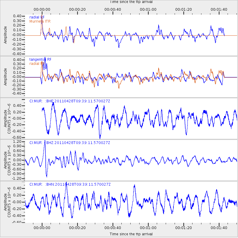
MUR Murrieta - Earthquake Result Viewer
*The percent match for this event was below the threshold and hence no stack was calculated.
| Earthquake location: |
Near East Coast Of Honshu, Japan |
| Earthquake latitude/longitude: |
37.5/141.7 |
| Earthquake time(UTC): |
2011/04/28 (118) 09:27:47 GMT |
| Earthquake Depth: |
38 km |
| Earthquake Magnitude: |
5.8 MB, 5.1 MS, 5.6 MW, 5.5 MW |
| Earthquake Catalog/Contributor: |
WHDF/NEIC |
|
| Network: |
CI Caltech Regional Seismic Network |
| Station: |
MUR Murrieta |
| Lat/Lon: |
33.60 N/117.20 W |
| Elevation: |
562 m |
|
| Distance: |
78.2 deg |
| Az: |
56.789 deg |
| Baz: |
307.086 deg |
| Ray Param: |
$rayparam |
*The percent match for this event was below the threshold and hence was not used in the summary stack. |
|
| Radial Match: |
70.555244 % |
| Radial Bump: |
400 |
| Transverse Match: |
73.11685 % |
| Transverse Bump: |
400 |
| SOD ConfigId: |
356183 |
| Insert Time: |
2011-10-01 10:06:26.922 +0000 |
| GWidth: |
2.5 |
| Max Bumps: |
400 |
| Tol: |
0.001 |
|
Signal To Noise
| Channel | StoN | STA | LTA |
| CI:MUR: :BHZ:20110428T09:39:11.570027Z | 2.8040915 | 5.9234475E-7 | 2.11243E-7 |
| CI:MUR: :BHN:20110428T09:39:11.570027Z | 0.8861164 | 1.6546974E-7 | 1.867359E-7 |
| CI:MUR: :BHE:20110428T09:39:11.570027Z | 1.412517 | 3.333127E-7 | 2.3597075E-7 |
| Arrivals |
| Ps | |
| PpPs | |
| PsPs/PpSs | |


