You are here: Home > Network List > IW - Intermountain West Stations List
> Station MOOW Moose Ponds, Wyoming, USA > Earthquake Result Viewer
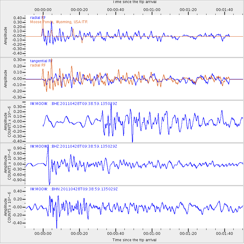
MOOW Moose Ponds, Wyoming, USA - Earthquake Result Viewer
*The percent match for this event was below the threshold and hence no stack was calculated.
| Earthquake location: |
Near East Coast Of Honshu, Japan |
| Earthquake latitude/longitude: |
37.5/141.7 |
| Earthquake time(UTC): |
2011/04/28 (118) 09:27:47 GMT |
| Earthquake Depth: |
38 km |
| Earthquake Magnitude: |
5.8 MB, 5.1 MS, 5.6 MW, 5.5 MW |
| Earthquake Catalog/Contributor: |
WHDF/NEIC |
|
| Network: |
IW Intermountain West |
| Station: |
MOOW Moose Ponds, Wyoming, USA |
| Lat/Lon: |
43.75 N/110.74 W |
| Elevation: |
2128 m |
|
| Distance: |
75.9 deg |
| Az: |
45.405 deg |
| Baz: |
308.561 deg |
| Ray Param: |
$rayparam |
*The percent match for this event was below the threshold and hence was not used in the summary stack. |
|
| Radial Match: |
67.21437 % |
| Radial Bump: |
400 |
| Transverse Match: |
54.52583 % |
| Transverse Bump: |
400 |
| SOD ConfigId: |
356183 |
| Insert Time: |
2011-10-01 10:19:45.345 +0000 |
| GWidth: |
2.5 |
| Max Bumps: |
400 |
| Tol: |
0.001 |
|
Signal To Noise
| Channel | StoN | STA | LTA |
| IW:MOOW: :BHZ:20110428T09:38:59.135029Z | 6.947447 | 5.1370097E-7 | 7.3940974E-8 |
| IW:MOOW: :BHN:20110428T09:38:59.135029Z | 1.730871 | 1.15622115E-7 | 6.679996E-8 |
| IW:MOOW: :BHE:20110428T09:38:59.135029Z | 1.9057242 | 1.1470194E-7 | 6.0188114E-8 |
| Arrivals |
| Ps | |
| PpPs | |
| PsPs/PpSs | |


