You are here: Home > Network List > MN - MEDNET Project Stations List
> Station TIP Timpagrande, Italy > Earthquake Result Viewer
TIP Timpagrande, Italy - Earthquake Result Viewer
*The percent match for this event was below the threshold and hence no stack was calculated.
| Earthquake location: |
Near East Coast Of Honshu, Japan |
| Earthquake latitude/longitude: |
37.5/141.7 |
| Earthquake time(UTC): |
2011/04/28 (118) 09:27:47 GMT |
| Earthquake Depth: |
38 km |
| Earthquake Magnitude: |
5.8 MB, 5.1 MS, 5.6 MW, 5.5 MW |
| Earthquake Catalog/Contributor: |
WHDF/NEIC |
|
| Network: |
MN MEDNET Project |
| Station: |
TIP Timpagrande, Italy |
| Lat/Lon: |
39.18 N/16.76 E |
| Elevation: |
789 m |
|
| Distance: |
88.4 deg |
| Az: |
320.377 deg |
| Baz: |
40.765 deg |
| Ray Param: |
$rayparam |
*The percent match for this event was below the threshold and hence was not used in the summary stack. |
|
| Radial Match: |
59.880257 % |
| Radial Bump: |
400 |
| Transverse Match: |
46.671715 % |
| Transverse Bump: |
400 |
| SOD ConfigId: |
356183 |
| Insert Time: |
2011-10-01 10:34:06.124 +0000 |
| GWidth: |
2.5 |
| Max Bumps: |
400 |
| Tol: |
0.001 |
|
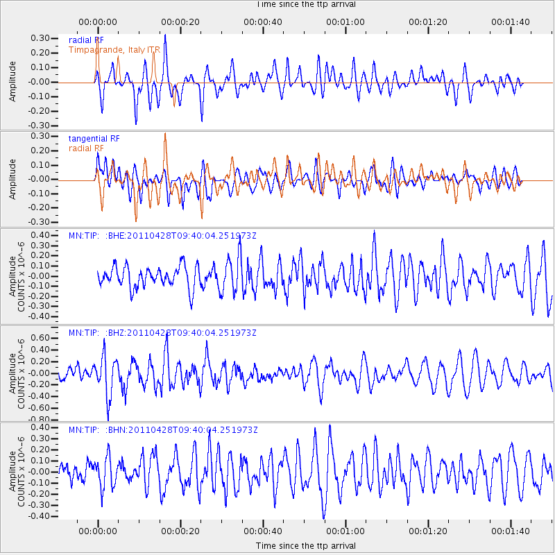
Signal To Noise
| Channel | StoN | STA | LTA |
| MN:TIP: :BHZ:20110428T09:40:04.251973Z | 2.5456858 | 3.398109E-7 | 1.3348502E-7 |
| MN:TIP: :BHN:20110428T09:40:04.251973Z | 1.7449257 | 1.388798E-7 | 7.959066E-8 |
| MN:TIP: :BHE:20110428T09:40:04.251973Z | 1.7655969 | 1.809587E-7 | 1.0249151E-7 |
| Arrivals |
| Ps | |
| PpPs | |
| PsPs/PpSs | |


