You are here: Home > Network List > TA - USArray Transportable Network (new EarthScope stations) Stations List
> Station E25A Miller Ranch, Amidon, ND, USA > Earthquake Result Viewer
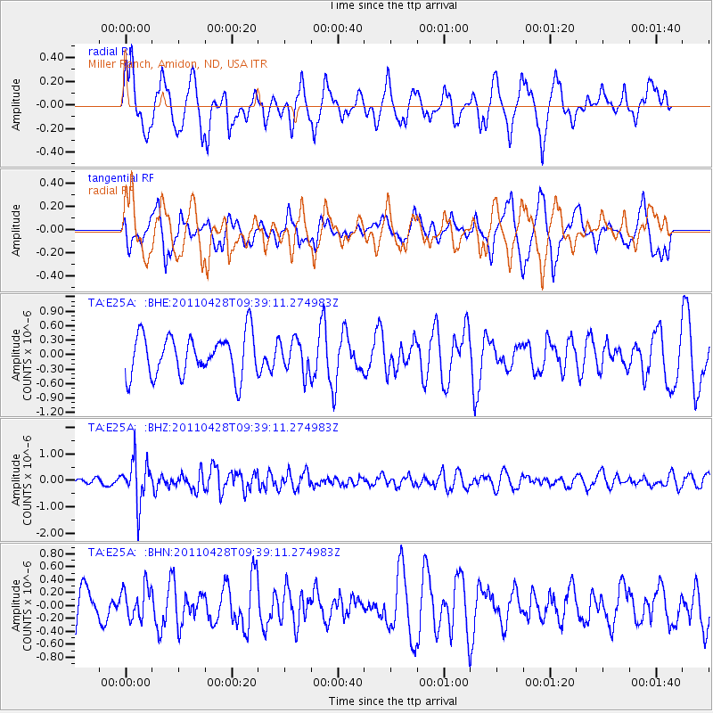
E25A Miller Ranch, Amidon, ND, USA - Earthquake Result Viewer
*The percent match for this event was below the threshold and hence no stack was calculated.
| Earthquake location: |
Near East Coast Of Honshu, Japan |
| Earthquake latitude/longitude: |
37.5/141.7 |
| Earthquake time(UTC): |
2011/04/28 (118) 09:27:47 GMT |
| Earthquake Depth: |
38 km |
| Earthquake Magnitude: |
5.8 MB, 5.1 MS, 5.6 MW, 5.5 MW |
| Earthquake Catalog/Contributor: |
WHDF/NEIC |
|
| Network: |
TA USArray Transportable Network (new EarthScope stations) |
| Station: |
E25A Miller Ranch, Amidon, ND, USA |
| Lat/Lon: |
46.50 N/103.40 W |
| Elevation: |
885 m |
|
| Distance: |
78.1 deg |
| Az: |
39.796 deg |
| Baz: |
312.492 deg |
| Ray Param: |
$rayparam |
*The percent match for this event was below the threshold and hence was not used in the summary stack. |
|
| Radial Match: |
61.692192 % |
| Radial Bump: |
400 |
| Transverse Match: |
58.744198 % |
| Transverse Bump: |
400 |
| SOD ConfigId: |
356183 |
| Insert Time: |
2011-10-01 11:00:07.520 +0000 |
| GWidth: |
2.5 |
| Max Bumps: |
400 |
| Tol: |
0.001 |
|
Signal To Noise
| Channel | StoN | STA | LTA |
| TA:E25A: :BHZ:20110428T09:39:11.274983Z | 5.629182 | 8.1896576E-7 | 1.4548576E-7 |
| TA:E25A: :BHN:20110428T09:39:11.274983Z | 0.8434364 | 2.4937043E-7 | 2.9566002E-7 |
| TA:E25A: :BHE:20110428T09:39:11.274983Z | 0.7922161 | 3.372289E-7 | 4.256779E-7 |
| Arrivals |
| Ps | |
| PpPs | |
| PsPs/PpSs | |


