You are here: Home > Network List > TA - USArray Transportable Network (new EarthScope stations) Stations List
> Station I28A Midland, SD, USA > Earthquake Result Viewer
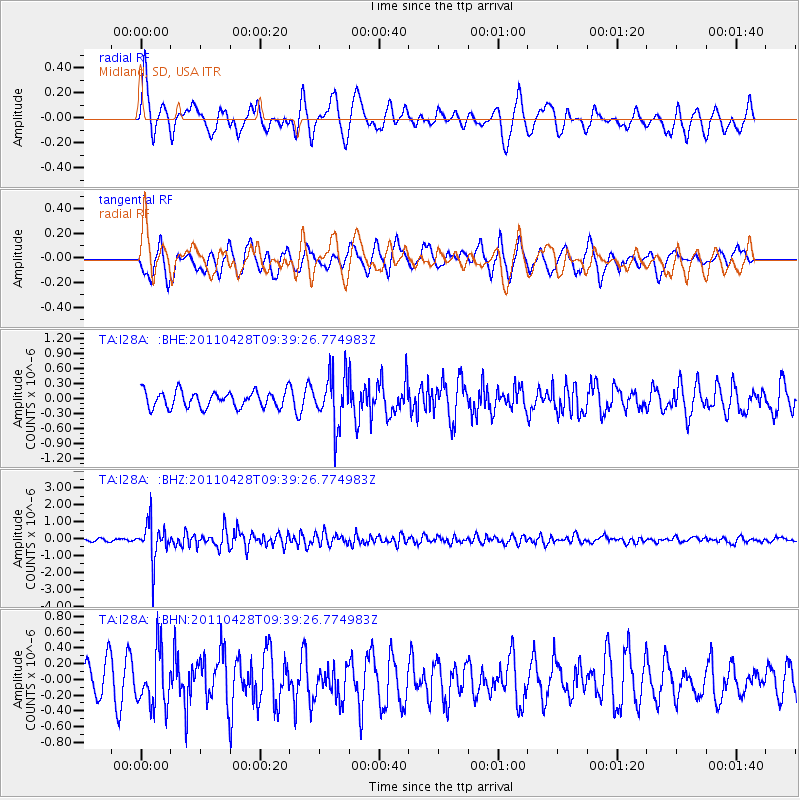
I28A Midland, SD, USA - Earthquake Result Viewer
*The percent match for this event was below the threshold and hence no stack was calculated.
| Earthquake location: |
Near East Coast Of Honshu, Japan |
| Earthquake latitude/longitude: |
37.5/141.7 |
| Earthquake time(UTC): |
2011/04/28 (118) 09:27:47 GMT |
| Earthquake Depth: |
38 km |
| Earthquake Magnitude: |
5.8 MB, 5.1 MS, 5.6 MW, 5.5 MW |
| Earthquake Catalog/Contributor: |
WHDF/NEIC |
|
| Network: |
TA USArray Transportable Network (new EarthScope stations) |
| Station: |
I28A Midland, SD, USA |
| Lat/Lon: |
44.00 N/101.17 W |
| Elevation: |
655 m |
|
| Distance: |
81.0 deg |
| Az: |
40.545 deg |
| Baz: |
314.208 deg |
| Ray Param: |
$rayparam |
*The percent match for this event was below the threshold and hence was not used in the summary stack. |
|
| Radial Match: |
71.21213 % |
| Radial Bump: |
400 |
| Transverse Match: |
60.430393 % |
| Transverse Bump: |
380 |
| SOD ConfigId: |
356183 |
| Insert Time: |
2011-10-01 11:01:23.382 +0000 |
| GWidth: |
2.5 |
| Max Bumps: |
400 |
| Tol: |
0.001 |
|
Signal To Noise
| Channel | StoN | STA | LTA |
| TA:I28A: :BHZ:20110428T09:39:26.774983Z | 11.287626 | 1.0929376E-6 | 9.682618E-8 |
| TA:I28A: :BHN:20110428T09:39:26.774983Z | 1.2089328 | 3.5176288E-7 | 2.9096978E-7 |
| TA:I28A: :BHE:20110428T09:39:26.774983Z | 3.1385577 | 5.043327E-7 | 1.6068932E-7 |
| Arrivals |
| Ps | |
| PpPs | |
| PsPs/PpSs | |


