You are here: Home > Network List > AZ - ANZA Regional Network Stations List
> Station SND AZ.SND > Earthquake Result Viewer
SND AZ.SND - Earthquake Result Viewer

| Earthquake location: |
Chile-Bolivia Border Region |
| Earthquake latitude/longitude: |
-21.7/-68.3 |
| Earthquake time(UTC): |
2002/03/28 (087) 04:56:22 GMT |
| Earthquake Depth: |
125 km |
| Earthquake Magnitude: |
6.1 MB, 6.5 MW, 6.5 MW |
| Earthquake Catalog/Contributor: |
WHDF/NEIC |
|
| Network: |
AZ ANZA Regional Network |
| Station: |
SND AZ.SND |
| Lat/Lon: |
33.55 N/116.61 W |
| Elevation: |
1358 m |
|
| Distance: |
71.6 deg |
| Az: |
318.944 deg |
| Baz: |
132.978 deg |
| Ray Param: |
0.053872988 |
| Estimated Moho Depth: |
13.0 km |
| Estimated Crust Vp/Vs: |
1.65 |
| Assumed Crust Vp: |
6.264 km/s |
| Estimated Crust Vs: |
3.802 km/s |
| Estimated Crust Poisson's Ratio: |
0.21 |
|
| Radial Match: |
94.244804 % |
| Radial Bump: |
400 |
| Transverse Match: |
86.64735 % |
| Transverse Bump: |
400 |
| SOD ConfigId: |
32974 |
| Insert Time: |
2010-02-26 20:56:42.677 +0000 |
| GWidth: |
2.5 |
| Max Bumps: |
400 |
| Tol: |
0.001 |
|
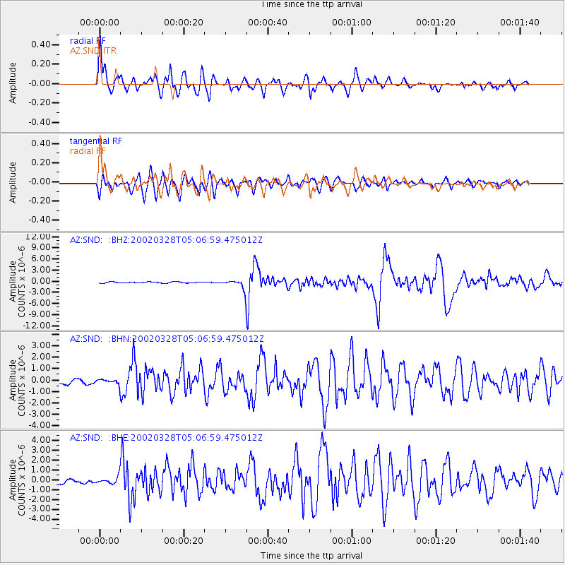
Signal To Noise
| Channel | StoN | STA | LTA |
| AZ:SND: :BHN:20020328T05:06:59.475012Z | 1.2071956 | 2.2107353E-7 | 1.8312983E-7 |
| AZ:SND: :BHE:20020328T05:06:59.475012Z | 1.7049211 | 3.7936942E-7 | 2.2251437E-7 |
| AZ:SND: :BHZ:20020328T05:06:59.475012Z | 8.790009 | 1.4628116E-6 | 1.6641754E-7 |
| Arrivals |
| Ps | 1.4 SECOND |
| PpPs | 5.3 SECOND |
| PsPs/PpSs | 6.7 SECOND |


