You are here: Home > Network List > TA - USArray Transportable Network (new EarthScope stations) Stations List
> Station I30A Oacoma, SD, USA > Earthquake Result Viewer
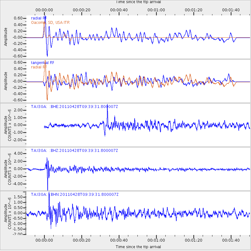
I30A Oacoma, SD, USA - Earthquake Result Viewer
*The percent match for this event was below the threshold and hence no stack was calculated.
| Earthquake location: |
Near East Coast Of Honshu, Japan |
| Earthquake latitude/longitude: |
37.5/141.7 |
| Earthquake time(UTC): |
2011/04/28 (118) 09:27:47 GMT |
| Earthquake Depth: |
38 km |
| Earthquake Magnitude: |
5.8 MB, 5.1 MS, 5.6 MW, 5.5 MW |
| Earthquake Catalog/Contributor: |
WHDF/NEIC |
|
| Network: |
TA USArray Transportable Network (new EarthScope stations) |
| Station: |
I30A Oacoma, SD, USA |
| Lat/Lon: |
43.91 N/99.43 W |
| Elevation: |
549 m |
|
| Distance: |
81.9 deg |
| Az: |
39.71 deg |
| Baz: |
315.29 deg |
| Ray Param: |
$rayparam |
*The percent match for this event was below the threshold and hence was not used in the summary stack. |
|
| Radial Match: |
76.73962 % |
| Radial Bump: |
400 |
| Transverse Match: |
71.34701 % |
| Transverse Bump: |
400 |
| SOD ConfigId: |
356183 |
| Insert Time: |
2011-10-01 11:32:26.602 +0000 |
| GWidth: |
2.5 |
| Max Bumps: |
400 |
| Tol: |
0.001 |
|
Signal To Noise
| Channel | StoN | STA | LTA |
| TA:I30A: :BHZ:20110428T09:39:31.800007Z | 14.144288 | 1.4326946E-6 | 1.0129139E-7 |
| TA:I30A: :BHN:20110428T09:39:31.800007Z | 3.4463267 | 5.969695E-7 | 1.7321906E-7 |
| TA:I30A: :BHE:20110428T09:39:31.800007Z | 5.09371 | 7.194883E-7 | 1.4125035E-7 |
| Arrivals |
| Ps | |
| PpPs | |
| PsPs/PpSs | |


