You are here: Home > Network List > TA - USArray Transportable Network (new EarthScope stations) Stations List
> Station V34A Guthrie, OK, USA > Earthquake Result Viewer
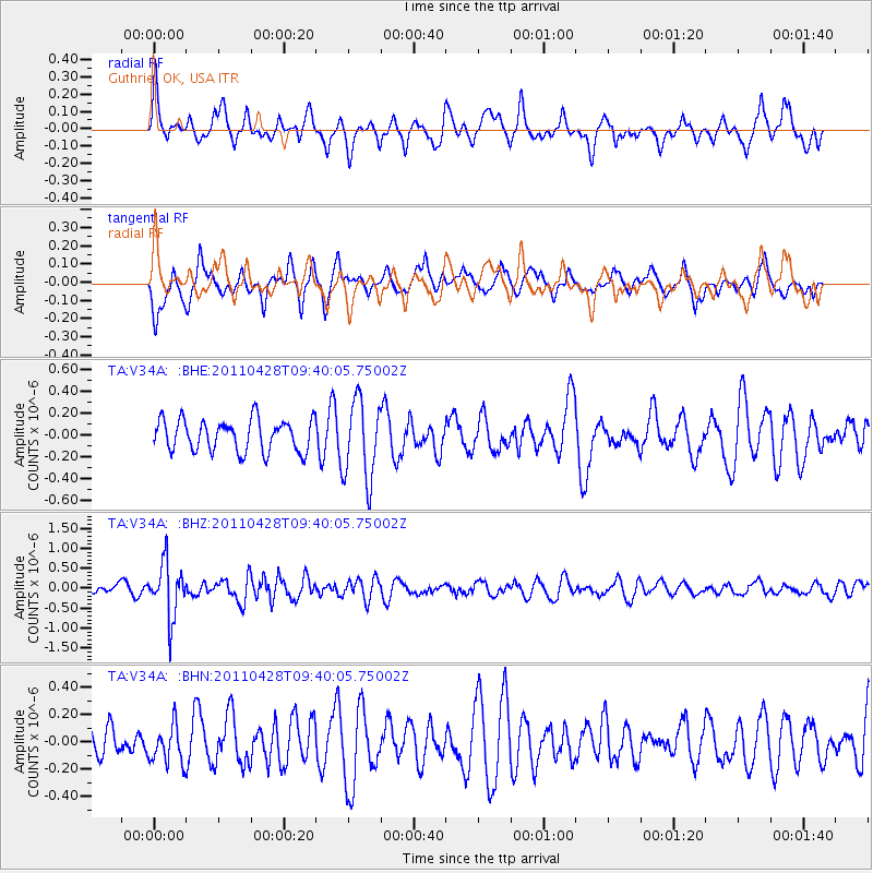
V34A Guthrie, OK, USA - Earthquake Result Viewer
*The percent match for this event was below the threshold and hence no stack was calculated.
| Earthquake location: |
Near East Coast Of Honshu, Japan |
| Earthquake latitude/longitude: |
37.5/141.7 |
| Earthquake time(UTC): |
2011/04/28 (118) 09:27:47 GMT |
| Earthquake Depth: |
38 km |
| Earthquake Magnitude: |
5.8 MB, 5.1 MS, 5.6 MW, 5.5 MW |
| Earthquake Catalog/Contributor: |
WHDF/NEIC |
|
| Network: |
TA USArray Transportable Network (new EarthScope stations) |
| Station: |
V34A Guthrie, OK, USA |
| Lat/Lon: |
35.83 N/97.52 W |
| Elevation: |
329 m |
|
| Distance: |
88.8 deg |
| Az: |
44.26 deg |
| Baz: |
316.882 deg |
| Ray Param: |
$rayparam |
*The percent match for this event was below the threshold and hence was not used in the summary stack. |
|
| Radial Match: |
48.176422 % |
| Radial Bump: |
363 |
| Transverse Match: |
64.939095 % |
| Transverse Bump: |
364 |
| SOD ConfigId: |
356183 |
| Insert Time: |
2011-10-01 11:44:48.883 +0000 |
| GWidth: |
2.5 |
| Max Bumps: |
400 |
| Tol: |
0.001 |
|
Signal To Noise
| Channel | StoN | STA | LTA |
| TA:V34A: :BHZ:20110428T09:40:05.75002Z | 6.081539 | 6.7228166E-7 | 1.10544654E-7 |
| TA:V34A: :BHN:20110428T09:40:05.75002Z | 0.919993 | 1.4195184E-7 | 1.5429666E-7 |
| TA:V34A: :BHE:20110428T09:40:05.75002Z | 2.5071301 | 3.6606727E-7 | 1.4601048E-7 |
| Arrivals |
| Ps | |
| PpPs | |
| PsPs/PpSs | |


